
If you are new to this blog, an intro. In 2016, we wanted to find more information about what could be called, Electric Geology, following the death of Michael Steinbacher. We were friends (online). During that time, we found a lot of very good and very interesting work by A.D. Hall, on Thunderbolts, at the EU (Electric Universe) Conferences, and on his blog. Of course, we updated and uploaded and published all of our e-zine Lists. We included many new EU links and EU-related links on those Lists, of course, and those included many new links about Electric Geology. Those were initially primarily Michael Steinbacher, but in 2016 many links were added from the work of A.D. Hall. During this time, we also found two Geology glossaries, which had “died”, “gone down”, and so on; that is, were not hosted online anymore. However, they were in the archives. So, below are reproduced the Geology Glossaries we liked best. We have edited the glossaries, added illustrations, and hope that you download it for your own use, or bookmark this page. Note: one Glossary was first written about 30 years ago, and was last updated in 2009.
Update: We have incorporated geological terms from the Encyclopedia of Quantavolution, by the late Prof. Alfred De Grazia, University of Chicago. We have also incorporated terms from the Geology Glossary of the University Of California Paleontology Museum.
Electric Geology Glossary
illustrated – click on any image to see it enlarged.
The small letter ‘c’, w/w/o parenthesis, refers to conventional geology or other sciences; the letter ‘q’ w/w/o parenthesis, refers to quantavolutionary geology or other sciences.
AAR GORGE – A 1.6 km (0.994 mi) long cut through a limestone ridge near Meiringen, Switzerland, carrying the torrent of the Aar River that arises from the Aar Glacier. The parent mountain is Finsteraarhorn, highest peak of the Bernese Alps. Walls of the cut reach 50 meters (164.042 feet), while its width is as narrow as one meter at its foot. The gorge derives an age of 10k (c) from the end of the Ice Age. Granted a constant flow, hence a slow startup until the definitive cut is made, the extent of ablation appears excessive. Alternatively, (q) the cut occurs originally as a fracture inviting the flood; or the initial torrent was exponentially greater, therefore able soon to initiate the cut. The famous theorist of the Ice Ages, Agassiz, built a hut by the Aar glacier to observe its behavior, engendering public curiosity and accelerating its popularity.
ABLATION – Removal of a part by melting or vaporization. Natural process removing, eroding, evaporating, or melting material in situ. Rates of ablation where calculable can be used to determine duration of ablated objects Thus, if the total diminution of glaciers consists typically of evaporation at a 5% per annum rate in the Northern Alps, the balance of ablation occurs in melt waters. But (q) climatic occurrences or (u) climatic shifts will affect both evaporation and melt rates.
ABRUPT TRANSFORM – Alteration of any kind, in anything, which is deemed to occur at the brief end of a time scale that is thought might be much longer. Actually the phrase may be used as a synonym for quantavolution. Thus in early science, Ovid and many others catalogued what they believed to have been instant metamorphoses of species, often “regressive” as well as “progressive,” for instance, a man turned to stone or ape; they claimed, too, sudden extreme changes of climate, atmosphere, soil, and topography. Applied to (q) and (c), the question of whether an event of the past required less rather than more time to transact or transform with other events of their medium may be most significant, comparable in importance to questions of the relative intensity of events and their scope. The (q) tends to believe that the rate of change peculiar to a given organism or natural process, measured at today’s rates, has been drastically altered at times by explosive transformation, including extinction of life forms. The change in question may be within and among star galaxies or in rates of radioactivity of a microscopic chemical element. It may refer to the evolution of species or the end of the ice ages. Hence this article can only format the problem and illustrate it, implying the logic and methods used to address it. A change may reveal itself in a substance or a motion, in a body or in a transaction between bodies, in an effect upon a third body or an effect upon a measure or index of the change. Thus a fossilized fern discloses family and individual features, and, if unique, sets up a species, suggesting then either a continuation or a change of kind. The fossilizing process is measured in relation to the surrounding medium, which must bear appropriate traits for inducing the fossilization. The age of the plant becomes the age of its case, the suddenness of the chemical process dates it; the date is determined by geological or chemical means, both controversial; if the plant is unique, its date in relation to dates accepted for other plants of the same family will suggest whether a sudden or long-term transition from one species to another has occurred. Obviously the longer the period between two events, the longer the sub-period between two sub-events, so that in astronomy and geology and evolution, as the time between original and current events has been lengthened, the time allowed for intermediate transformations has been increased. Thereupon, either abruptness is denied to as many events as possible, or an event is termed abrupt even if it takes many times the period hitherto assigned it; terms like “geologically sudden” and “astronomically gradual” are employed increasingly. Illustrations of the problem are numerous: a.) Two phytosaurian “reptiles” found in late Triassic rocks (soft, claylike matrix) in India contain smaller reptile skeletons in their stomach cavities; again, fossil fish remains have been found in throat sacs of pteranodan; in both situations, sudden disaster is indicated, and abrupt fossilizing conditions. b.)explosive volcanism can extinguish almost all life and pave vast areas around it for greatly varying areas, but the myriad extinct volcanoes point to a time when a great many volcanoes were exploding and erupting at the same time, and fissure volcanism has been responsible for remaking completely the morphology and later life forms of vast areas such as North-central Siberia and the Deccan Plateau. (A recently discovered ash layer in San Salvador covers 1300msq of a Mayan civilization.) Under such circumstances, ashes, gases and lava together can transform large sections of the global environment. c) [Geologist Joel] Cracraft argues that speciation is a “geologically instantaneous phenomenon.” d) Studies of generally occurring exoterrestrial iridium residues assert a shutdown of thousands of species from an obscuring of the Sun brought on by the dust of a meteoroid impact but whether the extinctions occurred in 3 months, 3 years, or millennia is hotly debated. All of these would be considered too short a time by (c) but some (q) exponents would even argue that 1ky is too long for a cosmic fallout of heavy material to have catastrophic effects on the species. Abrupt transform is sharply defined in recent studies of clay beds near Teapot Dome in Wyoming; there, in (q) 65my clay beds, investigators unearthed fossil land and water plants such as water lilies and lotus, akin to modern plants, whose cell structures indicated that they had been killed suddenly by freezing in the month of June. The sharp off-season winter lasted for 12 months, because the world was in darkness, the sun being unable to penetrate because of dust and gases from a meteor impact blanketing the sky. Even upon recovery, disaster would continue to strike, because then the sunlight would be let in but the atmosphere too choked with reaming dust and gas to let the heat out; a long wet greenhouse effect would destroy most remaining land biota. The presently feared destruction of the life-protecting, ultraviolet shielding ozone layer, on account of the abuse of supersonic plane flights, aerosols, etc., would be an abrupt transform without great Earth movements, wind noises, or oceanic turbulence, reminding one that ancient disasters might have occurred from the sky leaving little sign of their entrance or effects. The mammoths that have been found deep frozen, undisturbed, chewing plants, are examples; they hardly were terrified in certain cases, but were most likely so when found in a jumble of corpses. Investigation for the deep-freeze phenomenon must turn to exoterrestrial blasts of a cold gas, possibly cold helium that can asphyxiate and freeze stiff a large animal instantly, without a great change in absolute temperature. Debates about global warming, ozone depletion, deforestation, and pollution currently occupy great scientific and public attention; even as a consensus of imminent danger seems to be growing, the length of time years, decades, scores of years, centuries tests the methodology of scientists of several major fields, armed with budgets inordinately larger than the budgets of natural historiography.
ABYSS, OCEANIC – The bottoms of the ocean basins, by far the greater extent of the oceans (310 m sq km (119.692 sq mi)), largely plains, fractured around the world, dotted by myriads of volcanoes and seamounts, bounded on all sides by continental slopes. The abyss is a coating of basaltic igneous rock the same everywhere, product of the volcanic outpourings of the fracture system from the mantle of the Earth below. As the continents split asunder and rafted from one another, their huge blocks left behind a heated smooth bottom that was then paved over by the new volcanic material, like a roadbed laying machine following after a bulldozer. Beneath the coating lies an underside that is half the thickness of the floor, apparently not a product of lava flow but a melting and cooling of the lava in place. Depths of its water cover vary, averaging 4 km (2.485 mi). Abyssal rock is termed sima, rich in magnesium and silicon substance. Continental rock or sial (silicon and aluminum-rich) is found practically nowhere on the ocean bottoms unless it has detrited from the continents or fallen from the skies. The abyssal thickness is only one tenth that of the continents, which suggests that it is the product of a melt and that the oceans are new, and also it is more basic, less acid than the continental crust. Considering the extensive legends of the sinking of lands into the depths of the ocean, the expected abyssal continental sial does not exist there; one searches therefore for the source of such legends on the continental shelves, whether from contractions from fundamental cooling or increased water from outer space or melted ice caps and glaciers. The ocean basins are barely sedimented; they hold only 1% of all sediments. Under uniform conditions, this would represent only 16My of runoff debris totaling 10 exp 18 cu. tons 70). Dissolved solids in the oceanic waters total 3% of the aquatic mass, far from the extent of the difference, nor can these solids be attributed to continental detritus. The sediments are thickest on and at the base of the slopes; sediments of the abyss amount to a few meters of clay and ooze, incorporating a large amount of ash from aerial fallout and cosmic dust. The clay is igneous in origin. Pebbles, fish teeth and bones, and manganese nodules are sometimes encountered, and low hills, (c) ascribed to turbulent currents originating in earthquakes, the rotation of the Earth, or temperature shifts. The climate of the abyss is, however, fairly constant, and cold. Still, species do exist in scant numbers, unexceptionally species or varieties of species that are found near the surface, indicating either conditions inhospitable to life, a failure of evolution, or a newness of the abyss.
ABYSSAL PLAIN — The ocean floor offshore from the continental margin, usually very flat with a slight slope.
ACADIAN DISTURBANCE – Devonian period’s set of uplifts and sinkings, accompanied by heavy volcanism, settling large lava beds upon Northeastern North America (Francophone Canada, ergo Acadian). The White Mountains rose, with a granite core. Eastern Australian ranges also originated, providing estimated 10kthick igneous beds. The same species of animals are fossilized in North America and Europe, though ocean separates the two lands now. The Acadian upheavals are differently interpreted as gradual (c) and abrupt (q) and as distant and elongated in time (c = 340405My), (q = £1ky). The Old Red Sandstone of England is a controversial Devonian-Acadian event, proposing a million times longer by (c) than by (q).
ACCRETE — v. To add terranes (small land masses or pieces of crust) to another, usually larger, land mass.
ACCUMULATION, PRECIPITATE – snow, ice, or dust aggregates from atmospheric fall-outs, whether from near or far space. Glaciologists are most concerned with the history of frozen precipitates, especially as they accumulate and form ice caps which are supposed to draw upon the oceans for their growth and renewal. The present ice caps, as well as all of those of natural history, and especially in the several Ice Ages that are believed (c) to have occupied much of the Earth’s surface over long periods of time, are said to have grown up during the early Pleistocene, ~12my, owing to diminution in solar activity, increased dust clouds in the Earth’s atmosphere due to a plague of volcanism that would block the sun’s rays; both theories might be termed (q) but are allowed to take enough time to be called gradual. The fact that ice accumulates on mountaintops and in glaciers descending therefrom also promotes the theory that the ice caps form from perennial precipitation. The fact that the “Wisconsin” ice cap disappeared, leaving the minor caps of today, in a geological instant (therefore q) brings into question whether the origins as well as the demise of enormous accumulations of ice can occur without exoterrestrial (q) intervention. However, ice cores have been drilled in Antarctica and Greenland and appear to evidence to the eyes and by chemical test, annual layers of deposit; a sudden drop of ice blocks (q) would appear to be prohibited. If, on the other hand, the layered accumulation had been the product of heavy repeated hail and snow, the layers might be explained; a Noachian flood, that is, given an Earth with cold poles as today, would have been received upon the poles as ice and snow and preserved as such, with some layering. More likely in the two preceding hypothetical instances, the large blocks or the particle precipitation would both be below the area where annual varves are distinguishable (itself a hotly contested location in the cores). It is even difficult to determine whether snow is ample enough to increase accumulations of ice at test points in Greenland and Antarctica, or is more than ample. If the latter, and the flow off the bottom of the cap is constant, the time taken for the ice cap to generate would be short(q) and the age of the cap young; the fact that the very dwellings of the supervisors of the drilling operations are hoisted annually to escape burial in the snow would perhaps suggest a rapid rate of accumulation and an equally rapid rate of out-squeezing at the cap base.
ACHONDRITE – Stony meteorite that does not contain metallic particles in its crystal structure. It resembles terrestrial rocks. Its chemistry suggests achondrites were once melted or partially melted. (c) 90% of the meteorites that “fall” are stony, yet only half of the “finds,” confirmed meteorites, are stony.
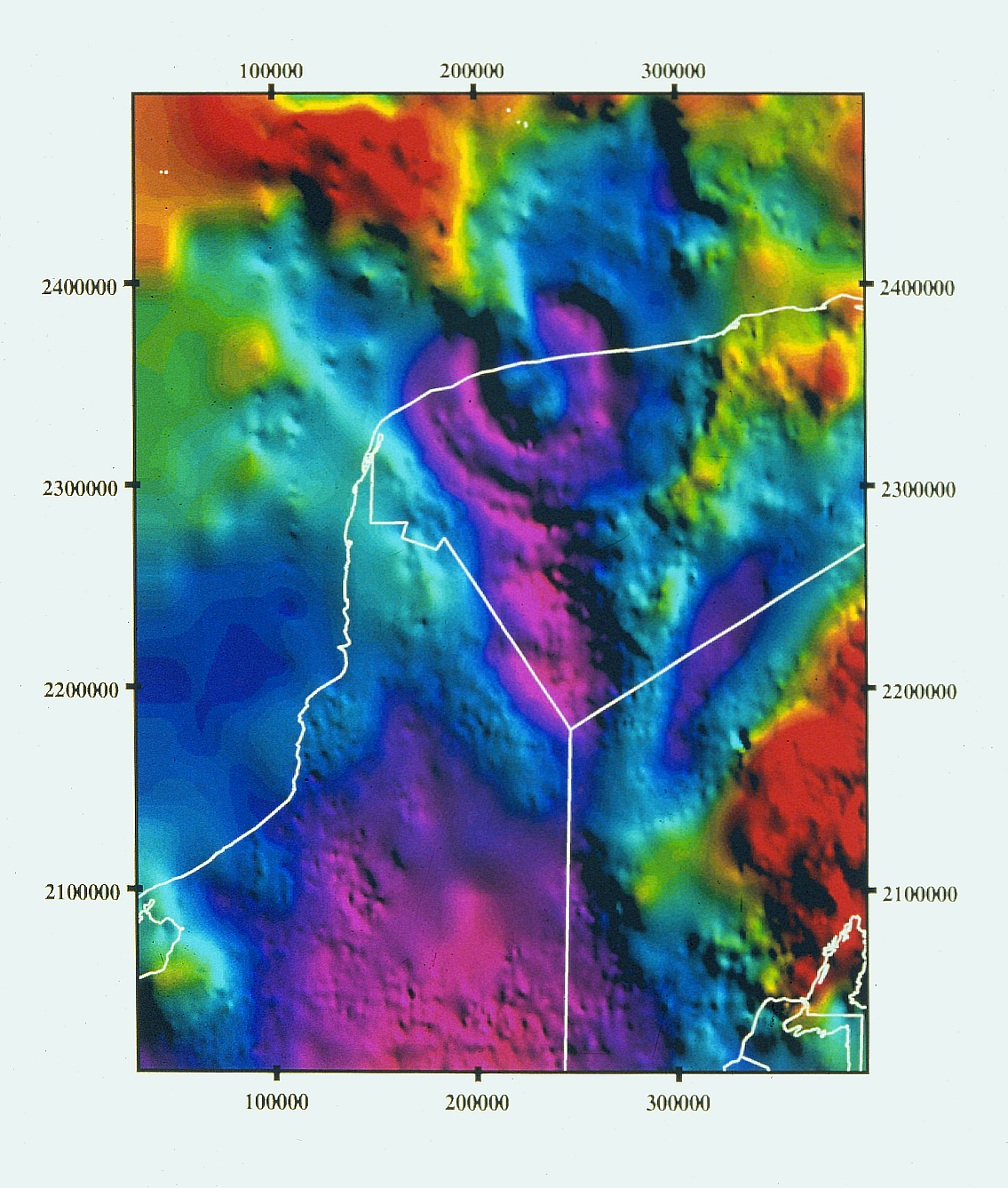
ACRAMAN – South Australia, Australia. The existence of this impact structure was deduced from the discovery of its ejecta layer within late Precambrian shales of the 590-million-year-old Bunyeroo Formation in the Adelaide geosyncline, South Australia. This layer contains abundant shocked quartz grains and small shatter cones. The ejecta were found in outcrops and drill cores over several hundred kilometers. These outcrops led scientists to the Acraman structure in South Australia, which was shortly thereafter confirmed as an impact structure, and as the source crater of the Bunyeroo impact ejecta layer. The diameter of the Acraman structure is at least 90 kilometers (55.923 miles), with some outer arcuate (bent or curved in the form of a bow) features at 150 kilometers (93.205 mi) diameter. Impact ejecta have been found at distances of up to 450 kilometers (279.617 mi) from the Acraman structure. The center of the structure is occupied by the 20-kilometer (12.427 mi)-diameter, hexagonal Lake Acraman, a dry salt lake (white feature slightly left of the center). It is not quite clear if the semicircular Lake Gairdner and Lake Everard, which can be seen in the upper part of the image, are part of the impact structure or not. If they are, Acraman would have a diameter of about 160 kilometers.
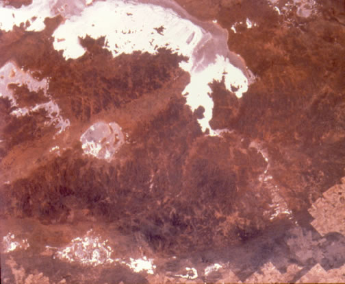
(Space shuttle image STS88-704-16.)
Location: 32°1’S, 135°27’E Diameter: ~90 kilometers (~55 miles) ( Age: ~590 million years.
ACRIDIDS – A family of orthopterous insects including the grasshopper. All the species of this family leap.
ADAPS–AVHRR Data Acquisition and Processing System. The EROS Data Center ADAPS, which began operation in May 1987, receives approximately 6 passes per day of HRPT data over the conterminous United States.
ADSORPTION – the formation of a layer of a material on the surface of a solid or a liquid. 1. Chemisorption involves chemical bonding of a single molecular layer of the absorbate to a surface. 2. Physisorption involves the weaker van der Waal’s force. Van der Waal’s force likely is electrostatic in origin: unlike the classical chemical bond no electrons are exchanged, rather, permanent or induced polarization within the adsorbed molecule allows surface charges to attract and hold the adsorbate.
AERIAL PHOTOGRAPHY – the recording of images concerning the Earth’s and planetary surfaces using methods that do not involve actual contact with the object or part of it being registered. Early aerial photographs generally were made from lowflying airplanes. As photographic emulsions with increased resolution and sensitivity to light were developed flights at higher altitudes could be used successfully to record greater expanses of surface in one view. In the case of astronomical bodies the first images were made photographically using telescopic cameras. In the more recent age of spacecraft, digital and video techniques have been combined with electronic stabilization of images to allow sensing to be done successfully from greater altitude and from platforms in space moving at large velocity relative to the target being sensed. In the beginning most records were recorded on photographic emulsions sensitive to energy in the near-ultraviolet, visible, and short-infrared, however supplemental information is obtained today using electronic and other detectors responding to narrow bands of energy both in the range of photographs and beyond it at both the high and low energy ends of the continuum. Stereoscopic images can be obtained using multiple overlapping images and by radar range measurements. Using this last technique the energy being recorded is transmitted from the recording station, is reflected by the surface being probed and the reflection is read by the detecting apparatus. Since the 1870’s, when the Moon and Sun were first photographed, the advantage of permanent images over visual observation and sketching have been apparent. Now most of the major bodies of the Solar System have been mapped, some only partially, over a wide range of energies. Comparison of images produced by using different energy ranges (radar, infrared, visible, and ultraviolet) allow information to be gained which helps estimate the biological, chemical, and physical status of the surfaces being sensed. Such information can not be gathered as simply by other methods. The overview provided by seeing the Earth from space has aided geologists immensely
AEROMAGNETIC – Aeromagnetic is descriptive of data pertaining to the Earth’s magnetic field which has been collected from an airborne sensor.
AFRICAN RIFT VOLCANISM – a wide belt of lava fields topped here and there by volcanoes, most inactive, beginning half way up the African Rift and accompanying the Rift until it strikes and joins the Indian Ocean/Red Sea fracture underwater, presenting therefore one of the greatest concentrations of continental volcanism in the world. The volcanism is assigned to the Tertiary, Miocene, in conjunction with the rifting process, although many of the craters are outside the confines of the rift belt. Remarkable at the north end, in the Afar, are several guyots, flat-topped volcanoes, of the type found in the scores of thousands in the ocean basins. (q) microchronal estimates view the scene as late Pleistocene, ignoring the welter of descriptive igneous rock types, claiming them as merely contemporary effusions of different type, without macrochronal significance.
AGATE – a stone of silica in the form of chalcedony which exhibits concentric bands of colors when seen in section. Agates are found in cavities in volcanic concretions and inside petrified logs. (c) believed processes involve the slow migration of mineral impurities into the rock matrix forming the agate. A plausible (q) mechanism precipitates out trace minerals present when siliceous material is destructively heated by volcanic material falling upon and freezing around local surface material, or when intensive electrical flows pass through a buried object. The local material is vaporized in an enclosed space. Agates are recovered near the center of the refrozen material.
AGRHYMET–AGRicultural, HYdrological and METeorological program. A West African AGRHYMET program which collects and disseminates environmental information on West Africa.
AHAGGAR MOUNTAINS – Algerian mountains rising in the heart of the Sahara desert. Mountain basin, 550,000 km² (212356.195 sq mi) in area is surrounded by higher Tassili Plateau.
Except to W, basin is bounded by steep sandstone cliffs. Mountains near edge of basin are not spectacularly high, no peaks exceed 800m (2624.672 feet). Highest central point rises 2918m (9573.491). Composed of metamorphic rocks of the African Shield, (c) dated 2G, the region is in part overlayed by volcanic rock, believed to be recent (M). (c) Folding and faulting followed formation of the African shield. Erosion supposedly reduced the region to a peneplain by 700M. The region was twice glaciated before it domed up removing sedimentary deposits and re-exposing the ancient bedrock. Because of the region’s complexity some authorities believe the region has been buried and re-excavated several times before 100M. Subsequent upwarping took place because molten material collected beneath the basin. Volcanism created the towering plugs which make up the most spectacular features of the Ahaggar region. Faulting has determined the path of several valleys some of which are followed by local streams. Rejuvenation followed eroding the peneplain into the topography that seen today. Evidence of erosion by freezing/thawing is present. (q) Northern mountains of Africa are possibly residues of globe circling belt of highlands bounding the early Tethys Sea. The sculpting of this complex region bears the signature of one or more short episodes of global catastrophism, which elsewhere produced uplift, volcanism, and intensive episodes of tidal scouring and exposed many parts of the Earth to ice falls and falls of debris.
AID–Agency for International Development. The United States Federal agency for international development projects.
ALBEDO – The percentage of incoming radiation that is reflected by a natural surface such as the ground, ice, snow, water, clouds, or particulates in the atmosphere.
ALBERS EQUAL AREA PROJECTION – The Albers Equal Area projection is a method of projection on which the areas of all regions are shown in the same proportion of their true areas. The meridians are equally spaced straight lines converging at a common point, which is normally beyond the pole. The angles between them are less than the true angles. The parallels are unequally spaced concentric circular arcs centered on the point of convergence of the meridians. The meridians are radii of the circular arcs. The poles are normally circular arcs enclosing the same angle as that enclosed by the other parallels of latitude for a given range of longitude. Albers Equal Area is frequently used in the ellipsoidal form for maps of the United States in the National Atlas of the United States, for thematic maps, and for world atlases. It is also used and recommended for equal-area maps of regions that are predominantly east-west in extent.
ALKALI METAL – the elements of the first group of the periodic table. They are lithium (Li), sodium (Na), potassium (K), rubidium (Rb), cesium (Cs) and Francium (Fr). Cesium, francium and some isotopes of rubidium are radioactive. Along with the non-metallic element hydrogen (H) the alkali metals have a single valence electron. This electron is readily lost forming a stable M + ion leaving the same outer electron configuration possessed by the noble gas elements adjacent to them in the periodic table. The alkali metals are highly reactive . Their atoms increase in size and density with atomic number. Their ionization energy declines with the atomic number of the atom. For (H it is 13.6 volts) Li it is 5.39 volts; Na 5.14 volts; K 4.34 volts; Rb 4.18 volts; and by Cs it has dropped to 3.89 volts; for Fr it is »4 volts. The second ionization requires much more energy (in Li 75.6 volts are required) and so M ++ ions are not found chemically. The melting and boiling points decrease as one goes from lithium to francium. They react with water and tarnish rapidly in air (by oxidation). The metals form strongly alkaline hydroxides which gives them their name. Their salts are generally soluble in water. They will react with chlorine, bromine, sulfur, and hydrogen. The elements lithium and sodium and some of their compounds are detected in stellar atmospheres and in plasma regions surrounding the planets.
ALKALINE — Term pertaining to a highly basic, as opposed to acidic, subtance. For example, hydroxide or carbonate of sodium or potassium.
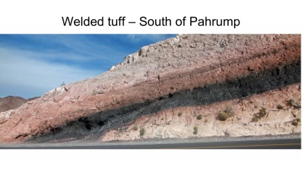
ALKALINE ROCK – igneous rocks containing a high amount of sodas are called alkaline. Some also contain significant lime (feldspar, hornblende, augite) and are called calc-alkali. Nearly all basic igneous rocks are basalts. Basalts are fine grained and are black or greenish-black in color. Pliny attributes their name to the Ethiopean word for black rock. Basalts are characterized by the presence of feldspars and pyroxene. Feldspars consist of potassium-aluminum silicate, sodium-aluminum silicate, and calcium-aluminum silicate in various forms. Pyroxenes are calcium, magnesium or iron metasilicates. Other metals may substitue for the three noted. Pyroxenes have the structure MSi0 3 (where M is the metal involved) in a crystal forming a stout prism. The mineral olivine [(Mg,Fe) 2 SiO 4 ] is found in basalts rich in magnesium. Rock glasses (like obsidian, 75% SiO 2 ) may be present, as may quartz [SiO 2 ] and calcite [CaCO 3 ]. More than 90% of all volcanic rocks are alkaline. When underground molten basalt is called magma. Magma contains a considerable amount of dissolved gas and vapor. As magma reaches the surface dissolved substances are freed (sometimes explosively). The still viscous basalt becomes lava which flows across the landscape until it freezes. Two major forms of lava exist; aa and pahoehoe. Lava dispersed explosively freezes into tiny fragments called ash which settles as tuff. Tuff may become consolidated into rock. Horizontal stratified accumulations of basalt hundreds of meters thick and covering up to 50,000 HA are called flood basalts. They are found in the Columbia Plateau of the NW United States, under the Altiplano of the S American Cordillera, and the Deccan Plateau in Western India. No major intrusions of basalt predate the Triassic Period. Investigation of the Nubian shield rocks in the E Desert of Egypt indicate six periods at which alkaline rocks came to the surface. All seem to coincide with abrupt changes in the mantle and surface elsewhere. The global nature of these events hint at a catastrophe happening to trigger the intrusions.
ALLOCHTHONOUS — Refers to something formed elswhere than its present location. Antonym of autochthonous.
ALLOGENIC SEDIMENT – sedimentary consolidated and unconsolidated material that is presently to be found in a location other than where it was originally deposited. The term covers so many types of sediment and modes of transfer that it can be applied practically everywhere. It needs only a minute shift in Earth motion, climate, meteorology, surface waters, folding and thrusting, sinking or rising or compression or relaxation, or any other spatial or location change to deprive organic or inorganic matter of its birthplace. The same motions usually change its composition. Certainly the study of sediments concerns in large part their dislocation. Many a debate of c/ and q/ ensues from doubts over the original position of fossils and sedimentary rocks. One q/ microchronal position regards all chronological distinctions based upon stratification as illusions created by the zoning of fossils through drift, flood, wind, and earth movements. This would be contradicted if c/ would present a table of randomly sampled sedimentary facies from around the world showing that the regularity of the c/ fossil and rock succession is statistically beyond question.
ALLUVIAL FAN — n. A fan-shaped deposit of sand, mud, etc. formed by a stream where its velocity has slowed, such as at the mouth of a ravine or at the foot of a mountain.
ALLUVIUM — n. a deposit of sand, mud, etc., formed by flowing water; alluvial – adj.
ANSI–American National Standards Institute. An ANSI standard implies a consensus of those substantially concerned with the scope and provisions of a product and is intended as a guide to aid the manufacturer, consumer, and the general public.
ANTHROPOGENIC – Relating to the scientific study of the origin of human beings and the results of their influence on nature.
ANTICLINE — A fold of rock layers that is convex upwards. Antonym of syncline.
APATITE – 1. a group of phosphate minerals, usually referring to hydroxylapatite, fluorapatite and chlorapatite, with high concentrations of OH−, F− and Cl− ions, respectively, in the crystal. The formula of the admixture of the four most common endmembers is written as Ca10(PO4)6(OH,F,Cl)2, and the crystal unit cell formulae of the individual minerals are written as Ca10(PO4)6(OH)2, Ca10(PO4)6(F)2 and Ca10(PO4)6(Cl)2. 2. (mineralogy)A common complex mineral consisting of calcium fluoride phosphate or calcium chloride phosphate, of variable composition; a source of phosphorus, sometimes used in the manufacture of fertilizer.
APFO–Aerial Photography Field Office. The U.S. Department of Agriculture’s APFO is managed by the Farm Service Agency (FSA). FSA was formerly known as the Agricultural Stabilization and Conservation Service (ASCS). APFO is the repository for all of the USDA’s aerial photography. The archive contains over 50,000 rolls of film acquired over the last 40 years and includes over 14 million frames of coverage of the conterminous U.S., Alaska, and Hawaii. APFO provides photographic products to local county, State and Federal offices within the U.S. Department of Agriculture (USDA) including FSA, National Resources Conservation Service (NRCS), and the Forest Service. They also serve the general public with similar products upon request at the cost of reproduction.
AQUIFER – a geologic formation that will yield water to a well in sufficient quantities to make the production of water from this formation feasible for beneficial use; permeable layers of underground rock or sand that hold or transmit groundwater below the water table
ARC EXPORT – EXPORT creates an ARC/INFO interchange file to transfer coverages, INFO data files, text files, and other ARC/INFO files between various computer systems. An interchange file contains all coverage information and appropriate INFO file information in a fixed length, ASCII format. It can be fully or partially compressed as well as uncompressed ASCII depending upon the given EXPORT option.
ARC SECOND – 1/3600th of a degree (1 second) of latitude or longitude.
ARC/INFO – ARC/INFO is a geographic information system (GIS) used to automate, manipulate, analyze, and display geographic data in digital form. ARC/INFO is a proprietary system developed and distributed by the Environmental Systems Research Institute, Inc., in Redlands, California.
DISCLAIMER: Any use of trade, product, or firm names is for descriptive purposes only and does not imply endorsement by the U.S. Government.
ArcUSA – Designed by ESRI, ArcUSA is a general-purpose database used to generate thematic maps of the conterminous United States at the State and county levels. The database contains cartographic information, tabular information, and indices and is designed for a wide range of applications.
AREAL – Relating to or involving an area.
ARTESIAN AQUIFER – a geologic formation in which water is under sufficient hydrostatic pressure to be discharged to the surface without pumping.
ASCENDING NODE – Direction satellite is traveling relative to the Equator. An ascending node would imply a northbound Equatorial crossing.
ASTROBLEME – an ancient crater. Typically, craters are recognized as round depressions with raised rims and central peaks, commonly thought to be caused by meteorite impacts. Another type of astrobleme can be created by an air-burst meteor, when no rocky meteorite material actually impacts the ground. Instead, the meteor explodes in the upper atmosphere, and its solid matter atomizes to form a bolide of plasma. The plasma fireball carries the same speed, trajectory, and energy as the original meteor, and essentially blow-torches the earth, creating the astrobleme. The “crater” in this case is typically a teardrop, or butterfly blast zone of ablated material with a hogback hill down the center. The long hogback is analogous to the central peak in a round crater, and is thought to be formed by blast melt sucked inward by supersonic winds in a central updraft, like those in the ‘stem’ of a thermonuclear mushroom cloud. This central hill, or blister, defines the path of the plasma bolide as it streaks down at an oblique angle. Astroblemes that are thought to have been caused by plasmoids or plasma bolides are also called ELECTROBLEMES.
ASTRODYNAMICS – The dynamics of celestial bodies including the motion and gravitation of natural and artificial objects in space.
ASTRONOMIC – Pertaining to the science of astronomy. Astronomy is the science of the heavenly bodies (fixed stars, planets, satellites, and comets) their nature, distribution, magnitudes, motions, distances, periods of revolution, eclipses, etc.
ATOMIC-ABSORPTION SPECTROPHOTOMETRY – This destructive analytical technique is used to determine concentrations of specific chemical elements based on their emission or absorption of specific wavelengths of electromagnetic radiation.
ATTRIBUTES – Attributes, also called feature codes or classification attributes, are used to describe map information represented by a node, line, or area. For example, an attribute code for an area might identify it to be a lake or swamp; an attribute code for a line might identify a road, railroad, stream, or shoreline.
AVHRR–Advanced Very High Resolution Radiometer. The AVHRR is a broad-band, 4 or 5 channel scanner (depending on the model), sensing in the visible, near-infrared, and thermal infrared portions of the electromagnetic spectrum. This sensor is carried on NOAA’s Polar Orbiting Environmental Satellites (POES), beginning with TIROS-N in 1978.
AZIMUTH – Azimuth is the angle of horizontal deviation, measured clockwise, of a bearing from a standard direction.
BASALT — Highly mafic igneous volcanic rock, typically fine-grained and dark in color; rough volcanic equivalent of gabbro.
BATHYMETRY – The measurement of depths of water in oceans, seas, and lakes. Also, the information derived from such measurements.
BIA–Bureau of Indian Affairs, Department of the Interior. The BIA serves Indian and Alaska Native tribes living on or near reservations. The BIA administers and manages approximately 52 million acres of land held in trust for Indians by the United States and works with local tribal governments on issues including road construction and maintenance, social services, police protection, and economic development.
BIL–Band-Interleaved-by-Line. BIL is a CCT tape format that stores all bands of satellite data in one image file. Scanlines are sequenced by interleaving all image bands. The CCT header appears once in a set.
BILINEAR – The term bilinear is referring to a bilinear interpolation. This is simply an interpolation with two variables instead of one.
BIOME – A community of living organisms in a single major ecological region.
BIP–Band-Interleaved-by-Pixel. When using the BIP image format, each line of an image is stored sequentially, line 1 all bands, line 2 all bands, etc. For example, the first line of a three-band image would be stored as p1b1, p1b2, p1b3, p2b1, p2b2, p2b3, where p1b1 indicates pixel one, band one, p1b2 indicates pixel one, band two, etc.
BIP-2–Band-Interleaved-by Pixel-Pair (CCT-X). BIP-2 is a CCT tape format available only for MSS data acquired before 1979. Data in each of four vertical swaths are stored in a separate image file. Scanlines are sequenced and interleaved-by-pixel- pairs. The CCT header information is recorded on each image file. BIP-2 is sometimes referred to as CCT-X format.
BLM–Bureau of Land Management, Department of the Interior. Under the Federal Land Policy and Management Act of 1976, the BLM administers and manages approximately 300 million acres of public lands primarily located in the western half of the lower 48 States and Alaska. Public lands in the U.S. contain mineral and timber reserves, support habitat for a host of wildlife, and provide recreational opportunities.
BOLIDE – A solid extraterrestrial object such as a meteorite, comet, or asteroid that explodes in the atmosphere. It is a fireball (-3 magnitude or brighter meteor) which ends in a visible explosion or burst or a bright terminal flash at its end, often with visible fragmentation. A bolide does not impact the earth’s surface, but rather arcs, explodes, and becomes a plasmoid, which does impact the earth’s surface.
BOR–Bureau of Reclamation, Department of the Interior. The BOR was chartered in 1902 with the responsibility to reclaim arid lands in the western U.S. for farming by providing secure, year-around water supplies for irrigation. The BOR’s responsibilities since have expanded to include generating hydroelectric power; overseeing municipal and industrial water supplies, river regulation, and flood control; enhancing fish and wildlife habitats; and researching future water and energy requirements.
BOSUMTWI, Ghana (impact crater) This well-preserved young crater, situated in crystalline bedrock of the West African Shield, is filled almost entirely by Lake Bosumtwi, which has a diameter of about 8 kilometers (4.971 miles).
Bosumtwi
The crater rim reaches elevations of about 300 meters (984.252 feet) above the lake level. Chemical, isotopic, and age studies demonstrate that the crater is the most probable source for the Ivory Coast tektites, which are found on land in Ivory Coast, West Africa, and as micro-tektites in nearby ocean sediments. The crater is excavated in 2.1-2.2-billion-year-old meta-sediments and meta-volcanics of the Birimian Supergroup. The rocks do not show any unambiguous evidence of shock metamorphism. Distinct impact-characteristic shock effects were identified only in clasts within suevite-derived melt fragments. The composition of the rocks is significantly more varied than that of the Ivory Coast tektites, but overlaps the tektite compositions. In this photo the crater lake is partly obscured by clouds, which is commonly the case in the area. (Space shuttle image STS51I-39-031.) Location: 06°32’N, 01°25’W. Rim diameter: 10.5 kilometers (6.524 miles). Age: 1.07 ±0.05 million years.
BOW SHOCK – also called a detached shock or normal shock, is a curved, stationary shock wave that is found in a supersonic flow past a finite body. The name comes from the example of a bow wave that forms at the bow of a ship when it moves through the water. A bow shock is a supersonic shock wave, an anvil of many thousands of psi, at a temperature many times that of the sun, carrying charged electric fields. In a dense, viscous environment, fluid mechanics, shock effects and electromagnetism align in phase and frequency with the arc that creates them.
BPI–Bits Per Inch. The tape density to which the digital data were formatted.
BRECCIA – 1. A rock composed of angular fragments either of the same mineral or of different minerals, etc., united by a cement, and commonly presenting a variety of colors. 2. Literally means ‘rubble’ and implies a rock deposited very close to the source area. Also applied to angular volcanic rocks from a volcanic vent. 3. a group of rocks consisting of angular, poorly sorted fragments of older rocks; distinguished from a conglomerate in that the component rocks are not rounded and worn.
BSQ–Band-Sequential. BSQ is a CCT tape format that stores each band of satellite data in one image file for all scan lines in the imagery array. The CCT headers are recorded on each band.
BYTE – Several (usually eight) binary bits of data grouped together to represent a character, digit, or other value.
CALCITE — A common crystalline form of natural calcium carbonate, CaCO3, that is the basic constituent of limestone, marble, and chalk. Also called calcspar.
CALDERA — n. A large circular volcanic depression, often originating due to collapse.
CALICHE — n. A sedimentary deposit commonly made of calcium carbonate and formed from the leaching of minerals from the top layers of soil. Caliche deposits characterize arid and semi-arid environments.
CALIPER – This is the method of examining the diameter of a drill hole to determine the hardness or softness of the individual rocks.
CARBON CYCLE – The natural cycle of carbon dioxide to carbohydrates by photosynthesis and its return to the atmosphere by animal metabolism and decomposition.
CARBONATE — n. A mineral composed mainly of calcium (Ca) and carbonate (CO3) ions, may also include magnesium (Mg), iron (Fe) and others. n. Rock or sediments derived from debris of organic materials composed mainly of calcium and carbonate (e.g., shells, corals, etc.) or from the inorganic precipitation of calcium (and other ions) and carbonate from solution (seawater). For example, limestone or dolomite. carbonate platform – n. A broad (hundreds of meters), flat, shallow submarine expanse of carbonate rock, more common in the early-middle Paleozoic. carbonate bank – n. A narrow (tens of meters), fairly flat, shallow, submarine plateau
of carbonate rock, more common from the middle-late Paleozoic to the present, e.g., the Bahama Banks.
CARTOGRAPHIC – Pertaining to cartography, the art or practice of making charts or maps.
CAVERN – a large underground opening in rock (usually limestone) which occurred when some of the rock was dissolved by water. In some igneous rocks, caverns can be formed by large gas bubbles.
CCT–Computer Compatible Tape. CCTs are 1/2-inch-wide magnetic tapes. The term is used in reference to both single tapes and tape sets consisting of a single logical volume of data.
CD-ROM–Compact Disc-Read Only Memory. CD-ROM is a computer peripheral that employs compact disc technology to store large amounts of data for later retrieval. The capacity of a CD-ROM disk is over 600 megabytes, the equivalent of over 250,000 typewritten pages.
CENTRAL PEAK – the exposed core of uplifted rocks in complex meteorite impact craters. The central peak material typically shows evidence of intense fracturing, faulting, and shock metamorphism.
CHALK — A soft compact calcite, CaCO3, with varying amounts of silica, quartz, feldspar, or other mineral impurities, generally gray-white or yellow-white and derived chiefly from fossil seashells.
CHANNELS – A range of wavelength intervals selected from the electromagnetic spectrum.
CHERT — Hard, dense sedimentary rock, composed of interlocking quartz crystals and possibly amorphous silica (opal). The origin of the silica is normally biological, from diatoms, radiolaria or sponge spicules. Synonymous with flint.
CHIP – A chip is an image subset window and is used in the correlation process.
CHICXULUB, Yucatán, Mexico – The Chicxulub structure is not exposed on the surface; thus, only geophysical images give evidence of its presence and extent.
This image shows the variations in the magnitude of the gravity field at sea level in the vicinity of the buried Chicxulub impact basin in the northwestern corner of the Yucatán Peninsula, Mexico. In general, lower than normal gravity variations (so-called negative anomalies) indicate that the near-surface crustal rocks have relatively low densities; this could indicate fracturing and other structural disturbances that increase the volume of normal rocks or could be due to infilling by low-density carbonate sediments. Positive gravity anomalies indicate dense rocks such as the low-porosity impact melt sheet or up-thrust deep crustal rocks. A gravity anomaly over the Chicxulub basin ranges from lows exceeding -15 mGals (1 milligal = 10 -5 m/s 2 ; magenta) to +54 mGal (red). The Chicxulub basin is expressed as a broad, nearly circular region in which gravity values are 20-30 mGal lower than regional values. A distinct 15- to 20-mGal high occupies the geometric center at 21.3°N latitude and 89.6°W longitude. Surrounding this high are clearly discernible ring-like variations in the gravity field. The pronounced ring that separates the deep annular basin (magenta and deep blue regions) from the basin flanks (cyan and green) has a diameter of ~200 kilometers (124.274 miles). A discontinuous, subtle outer ring with a diameter of ~250-280 kilometers (~155 – 174 miles) can be discerned particularly toward the southern part of the basin. The image has been artificially shaded using a low illumination angle from the north to emphasize broad low-amplitude anomalies. All data have been Bouguer corrected using a model slab density of 2200 km/m 3 . Numbers along the margins of the image refer to Universal Transverse Mercator coordinates given in meters. The irregular white line marks the shoreline of the Yucatán Peninsula, and the straight lines mark province borders. (Image courtesy of V. L. Sharpton.) Location: 21.3°N 89.6°W. Diameter: ~250-280 kilometers (~155 – 174 miles). Age: 64.98 ± 0.05 million years.
CINDER CONES – A conical hill, often steep, formed by accumulation of solidified fragments of lava that fall around the vent of a single basaltic or andesitic eruption. The rock fragments, often called cinders or scoria, are glassy and contain numerous gas bubbles “frozen” into place as magma exploded into the air and then cooled quickly. Cinder cones range in size from tens to hundreds of meters tall. Cinder cones usually erupt lava flows, either through a breach on one side of the crater or from a vent located on a flank. Lava rarely issues from the top (except as a fountain) because the loose, non cemented cinders are too weak to support the pressure exerted by molten rock as it rises toward the surface through the central vent. Perhaps the most famous cinder cone, Paricutin, grew out of a corn field in Mexico in 1943 from a new vent. Eruptions continued for 9 years, built the cone to a height of 424 meters (1391.076 feet), and produced lava flows that covered 25 sq km (9.652 sq mi). Cinder cones are commonly found on the flanks of shield volcanoes, stratovolcanoes, and calderas. For example, geologists have identified nearly 100 cinder cones on the flanks of Mauna Kea, a shield volcano located on the Island of Hawai`i (these cones are also referred to as scoria cones and cinder and spatter cones).
CLAST — n. An individual grain or constituent of a rock; clastic- adj. Describes a rock or sediment composed mainly of fragments of preexisting rocks or minerals that have been transported some distance from their place of origin, e.g., sandstone, shale.
CLEARWATER LAKES, Quebec, Canada –
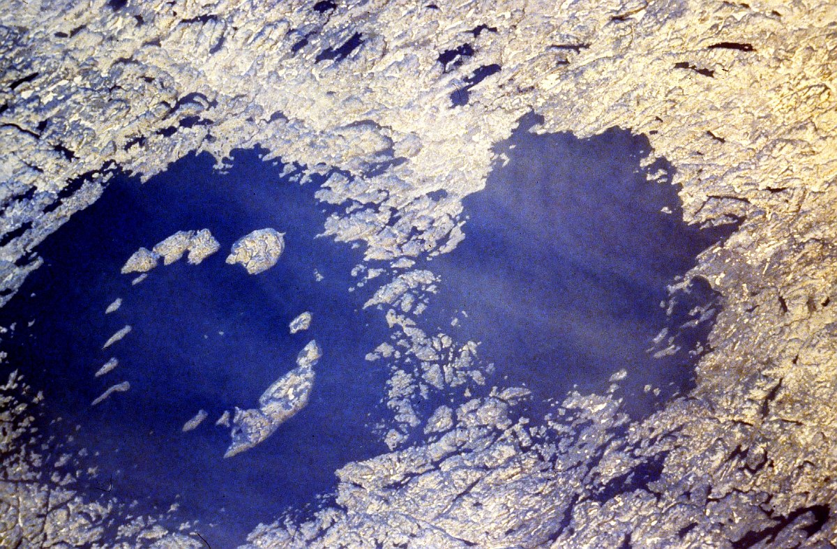
Clearwater Lakes
Twin impact craters, which are formed simultaneously by two separate, but probably related, meteorite impacts, are very rarely recognized on Earth. This pair is situated in crystalline bedrocks of the Canadian Shield. The larger Clearwater Lake West (left) shows a prominent ring of islands that has a diameter of about 10 kilometers (6.214 miles). They constitute a central uplifted area and are covered with impact melts. The central peak of the smaller Clearwater Lake East (right) is submerged. (Space shuttle image STS61A-35-86.)
Clearwater Lake West: Location: 56°13’N, 74°30’W. Original rim diameter: 36 kilometers (22.368 miles).
Clearwater Lake East: Location: 56°05’N, 74°07’W. Original rim diameter: 26 kilometers (16.155 miles). Age: 290 ± 20 million years
CLIMATOLOGY – The science of climates and their phenomena.
CLUSTER – A homogeneous group of units which vary “like” one another. “Likeness” is usually determined by the association, similarity, or distance among the measurement patterns associated with the units.
CONCATENATE – In the LAS environment, concatenate is the overlaying of an input image with one image or a series of images using the lines and samples to calculate the projection coordinates in the creation of a mosaic image.
CONCRETION — n. A hard, rounded mass, commonly of silica, calcite, dolomite, iron oxide, pyrite, or gypsum, that formed within a rock from the precipitation of these minerals around a nucleus, such as a leaf, bone, shell, or fossil, and ranging in diameter from centimeters (inches) to meters (yards).
CONFORMAL – A map projection that has the property of true shape (conformality). On a conformal projection scale is the same in every direction from any point on the map, thus deformation of scale increases regularly in all directions. Parallels and meridians intersect at right angles and the shapes of very small areas (“orthomorphic”), and angles with very short sides are preserved. As there is no angular deformation, and true angles are maintained, angular measurements can be made from conformal projections.
CONGLOMERATE — A coarse-grained sedimentary rock, with clasts larger than 2 mm (0.079 in).
CONTOUR – Imaginary line on the ground, all points of which are at the same elevation above or below a specified datum.
CONVOLUTON – On a conformal projection, scale is the same in every direction from any point on the map, thus deformation of scale increases regularly in all directions. Parallels and meridians intersect at right angles and the shapes of very small areas (“orthomorphic”), and angles with very short sides are preserved. As there is no angular deformation, and true angles are maintained, angular measurements can be made from conformal projections. In complex analysis, mappings that preserve angles are called conformal, in geometry they are said to be isogonal.
CORDILLERA, (from old Spanish cordilla, “cord,” or “little rope”), a system of mountain ranges that often consist of a number of more or less parallel chains. Cordilleras are an extensive feature in the Americas and Eurasia. In North America the Rocky Mountains, the Sierra Nevadas, and the mountains between them are collectively known as the Cordilleras, and the entire area has been termed the Cordilleran region. The term Cordillera is used with a directional modifier (e.g., Cordillera Oriental) to differentiate the various chains of the Andes Mountains as they extend through Colombia, Venezuela, Bolivia, and other countries in South America.
CORONA EFFECT – The Corona Effect occurs when electricity is discharged into the surrounding atmosphere from a high voltage source. When an alternating current is made to flow across two conductors of the transmission line whose spacing is large compared to their diameters, then air surrounding the conductors (composed of ions) is subjected to di-electric stress. At low values of supply end voltage, nothing really occurs as the stress is too less to ionize the air outside. But when the potential difference is made to increase beyond some threshold value of around 30 kV known as the critical disruptive voltage, then the field strength increases and then the air surrounding it experiences stress high enough to be dissociated into ions making the atmosphere conducting. This results in electric discharge around the conductors due to the flow of these ions, giving rise to a faint luminescent, violet glow, along with the hissing sound accompanied by the liberation of ozone, which is readily identified due to its characteristic odor. This phenomenon of electrical discharge occurring in transmission line for high values of voltage is known as the corona effect in power system. If the voltage across the lines is still increased the glow becomes more and more intense along with hissing noise, inducing very high power loss into the system which must be accounted for. RFI and third harmonics are also generated.
COVARIANCE MATRIX – A matrix containing the expected values derived from the products of the deviations of pairs of random variables from their means. Covariance measures the extent to which two random numbers vary together (i.e., varying at the same rate in the same direction).
CPES–Control Point Extraction System, software used to produce and process a single-band (Band 4) Landsat chip.
CPT–Control Point. CPTs are features of known ground location that can be accurately located on imagery.
CRATONS – 1. The relatively stable portions of continents composed of shield areas and platform sediments; typically, cratons are bounded by tectonically active regions characterized by uplift, faulting and volcanic activity. A part of the Earth’s crust that has attained stability and has been little deformed for a long period of time; refers only to continents. 2. shaped like a volcano.
CRITICAL DISRUPTIVE VOLTAGE – is the minimum phase-neutral voltage at which corona occurs.
CRYOSPHERE – The part of the Earth’s surface that is perennially frozen; the zone of the Earth where ice and frozen ground are formed.
CUBIC CONVOLUTION – A high order resampling technique in which the brightness value of a pixel in a corrected image is interpolated from the brightness values of the 16 nearest pixels around the location of the corrected pixel.
DACS–Data Acquisition and Control Subsystems, NOAA’s header quality information file.
DANGLING ARC – An arc having the same polygon on both its left and right sides and having at least one node that does not connect to any other arc. See dangling node.
DANGLING NODE – The dangling endpoint of a dangling arc. Often identifies that a polygon does not close properly (e.g., undershoot), that arcs do not connect properly, or that an arc was digitized past its intersection with another arc (e.g., overshoot). In many cases, a dangling node may be acceptable. For example, in a street centerline map, cul-de-sacs are often represented by dangling arcs.
DATUM – In surveying, a reference system for computing or correlating the results of surveys. There are two principal types of datums: vertical and horizontal. A vertical datum is a level surface to which heights are referred. In the United States, the generally adopted vertical datum for leveling operations is the national geodetic vertical datums of 1929 (differing slightly from mean sea level). The horizontal datum, used as a reference for position, is defined by: the latitude and longitude of an initial point, the direction of a line between this point and a specified second point, and two dimensions which define the spheroid. In the United States, the initial point for the horizontal datum is located at Meades Ranch in Kansas.
DBMS–Data Base Management System. A DBMS is software that supports processes germane to organizing, cataloging, locating, storing, retrieving, and maintaining data (i.e., information) in a data base.
DCRsi–Digital Cassette Recording system incremental. The DCRsi rack mount and modular ruggedized systems are one-inch, transverse scan, rotary digital recorders capable of recording and reproducing at any user data rate from 0 to 13.4 Mbytes/seconds (0-107 Mbits/seconds). DCRsi is a user friendly mass storage data peripheral with a total storage capacity of 48 gigabytes.
DDR–Data Descriptor Record. A DDR is a file containing image information which may include: (1) number of lines, number of samples, number of bands, data type, and the system on which the data was created; (2) corner coordinates of the image and related projection information; (3) the minimum and maximum values for each band of an image; (4) information describing how and when each band of the image was acquired; and (5) miscellaneous information (e.g., the last date and time modifications were made to an image).
DELAYED NEUTRON ACTIVATION ANALYSIS – This non-destructive analytical technique is used to determine concentrations of specific chemical elements. The procedure is based on artificially induced neutron capture and the radioactive decay constants of unstable radio-nuclides that are produced.
DEM–Digital Elevation Models. The U.S. Geological Survey produces five primary types of digital elevation model data. They are:
7.5-minute DEM (30- x 30-m data spacing, cast on Universal Transverse Mercator (UTM) projection or 1- x 1-arc-second data spacing). Provides coverage in 7.5- x 7.5-minute blocks. Each product provides the same coverage as a standard USGS 7.5-minute map series quadrangle. Coverage: Contiguous United States, Hawaii, and Puerto Rico. 1-degree DEM (3- x 3-arc-second data spacing). Provides coverage in 1- x 1-degree blocks. Two products (three in some regions of Alaska) provide the same coverage as a standard USGS 1-x 2-degree map series quadrangle. The basic elevation model is produced by or for the Defense Mapping Agency (DMA), but is distributed by USGS in the DEM data record format. Coverage: United States. 30-minute DEM (2- x 2-arc-second data spacing). Consists of four 15- x 15-minute DEM blocks. Two 30-minute DEMs provide the same coverage as a standard USGS 30- x 60-minute map series quadrangle. Saleable units will be 30- x 30-minute blocks, that is, four 15- x 15-minute DEMs representing one half of a 1:100,000-scale map. Coverage: Contiguous United States, Hawaii. 15-minute Alaska DEM (2- x 3-arc-second data spacing, latitude by longitude). Provides coverage similar to a 15-minute DEM, except that the longitudinal cell limits vary from 20 minutes at the southernmost latitude of Alaska to 36 minutes at the northern most latitude limits of Alaska. Coverage of one DEM will generally correspond to a 1:63,360-scale quadrangle. 7.5-minute Alaska DEM (1- x 2-arc-second data spacing, latitude by longitude). Provides coverage similar to a 7.5-minute DEM, except that the longitudinal cell limits vary from 10 minutes at the southernmost latitude of Alaska to 18 minutes at the northernmost latitude limits of Alaska.
DEMODULATION – The process of recovering a signal from a modulated (varied frequency) carrier wave.
DESCENDING NODE – Direction satellite is traveling relative to the Equator. A descending node would imply a southbound Equatorial crossing.
DIAPLECTIC GLASS – A natural glass formed by shock pressure from any of several minerals without melting; it is found only in association with meteorite impact craters and crater ejecta.
DIGITAL COUNT – Digital count is the total number of pixels occurring in an image for each possible data value.
DIGITIZATION – Digitization of graphics typically involves recording the location of each point, line, and polygon on a map, along with their associated labels and attributes.
DIORITE — Igneous plutonic rock, less mafic than gabbro, but more mafic than granite and granodiorite; rough plutonic equivalent of andesite.
DIP — The angle that a bedding plane or fault makes with the horizontal when measured perpendicular to the strike of the bedding plane or fault.
DISTAL EJECTA – impact ejecta found at distances greater than 5 crater radii from the rim of the source crater, as opposed to proximal ejecta, which are found closer than 5 crater radii from the crater rim, and which make up about 90% of all material thrown out of the crater during the impact event.
DLG–Digital Line Graph. A DLG is line map information in digital form. The DLG data files include information about planimetric base categories, such as transportation, hydrography, and boundaries.
DLG OPTIONAL FORMAT – The USGS digital line graph (DLG-3) optional format, which was designed for data interchange, allows for the creation of a vector polygon data structure. The topological linkages are explicitly encoded for node, area, and line elements. The files are composed of 8-bit ASCII characters organized into fixed logical records of 80 bytes. Bytes 1 – 72 contain the data, bytes 73 – 77 are blank, and bytes 78 – 80 contain a record sequence number. The detailed description of the DLG-3 optional format is described in Digital Line Graphs from 1:2,000,000-Scale Maps, Data Users Guide 3 (1990).
DLG STANDARD FORMAT – The DLG Standard Format is no longer distributed. Designed to minimize data storage, the topological linkages of the USGS DLG standard format are only contained in the line elements. The files are comprised of standard 8-bit ASCII characters organized into fixed length records of 144 bytes. Nine distinct record types are defined in this format. Coordinates are expressed as integer mils (one unit = .001″) in a Cartesian coordinate system. The origin is positioned at the center of the DLG cell. The coordinate domain is limited to the range -32768 and +32767. These values must be transformed using coefficients stored in the header record of the file to convert to the original Albers Equal-Area coordinates.
DMA–Defense Mapping Agency. The DMA was established in 1972, when mapping, charting, and geodesy functions of the Defense Community were combined into this joint Department of Defense agency. The mission of the Agency is to: produce and distribute to the Joint Chiefs of Staff, unified and specified commands, military departments, and other department of defense users, timely and uniquely tailored mapping, charting, and geodetic products, services, and training; provide nautical charts and marine navigational data to worldwide merchant marine and private vessel operators; and maintain liaison with civil agencies and other national and international scientific and other organizations engaged in mapping, charting, and geodetic activities.
The above activities were handled by the DMA Combat Support Center until the Center was disbanded in 1995 and responsibilities were transferred to the National Imagery Mapping Agency.
DODGING – Dodging is a process used to lighten areas of a photographic print during the main exposure so that the areas which need lightening receive less than the regular exposure. This process, which generally provides more image detail and reduces scene contrast, is performed by a skilled technician using their hands or a paddle over the area in need of less exposure.
DOLOMITE — A carbonate sedimentary rock composed of more than 50 percent of the mineral calcium-magnesium carbonate (CaMg(CO3)2).
DOMSAT–Domestic Satellite. A system that utilizes a geosynchronous satellite to re-broadcast satellite data received at a central reception and preprocessing center.
DOPPLER SYSTEM – The Doppler system is used to correlate total aeromagnetic readings with the position of the aircraft at the instant readings are taken. The information is then used for mapping aeromagnetic data. The Doppler system is self contained in the aircraft and emits a pulsed or continuous microwave which is sent diagonally downward fore and aft. The frequencies are then compared in order to obtain true ground speed. The heading is obtained from a special magnetic compass and is maintained by a directional gyro used as an integrating device. The distance thus determined has a precision better than one part in a thousand, which is sufficient for most geophysical surveys.
DOUGLAS – PEUCKER – An algorithm developed by David H. Douglas (University of Ottawa) and Thomas K. Peucker (Simon Fraser University, British Columbia). This formula was designed to reduce the number of points required to represent a digitized line from a map. Reducing the number of points saves storage space and also allows for generalization of lines that are very complex.
DRAINAGE BASIN – Geographic area or region containing one or more drainage areas that discharge run-off to a single point.
DTM–Digital Terrain Model, a land surface represented in digital form by an elevation grid or lists of three-dimensional coordinates.
ECOSYSTEM – An ecologic system composed of interacting organisms and their environments. The result of interaction between biological, geochemical and geophysical systems.
EDAC–Earth Data Analysis Center. EDAC, also known as the Technology Applications Center (TAC), has served as a NASA center since 1964. EDAC operates under the objective of transferring Earth-observing technologies to the user community. It supports and works directly with industries developing technologies related to space science and collaborating with them to enhance and encourage the user community to adopt the new technologies. EDAC also supports and works with public agencies, private citizens, educational organizations, and volunteer groups to ensure ready accessibility to NASA generated space imagery.
EDC–Earth Resources Observation Systems Data Center. EDC is a national archive, production, distribution, and research facility for remotely sensed data and other geographic information. See also EROS.
EIPS–Space Imaging Image Processing System. EIPS is software that calculates the maximum number of image lines that can be consolidated into a tape record.
ELECTROMAGNETIC SPECTRUM – Electromagnetic radiation is energy propagated through space between electric and magnetic fields. The electromagnetic spectrum is the extent of that energy ranging from cosmic rays, gamma rays, X-rays to ultraviolet, visible and infrared radiation including microwave energy.
EMISSION SPECTROGRAPHY – This destructive analytical technique is used to determine concentrations of specific chemical elements based on their emission or absorption of specific wavelengths of electromagnetic radiation.
EPA–Environmental Protection Agency. Established on December 2, 1970, the EPA is charged with protecting and enhancing the environment for present and future generations to the fullest extent possible under Congressional law with responsibilities including the control of solid waste, pesticides, radiation, and toxic substances, and the abatement of air and water pollution. The EPA coordinates research and antipollution activities with State and local governments, educational institutions, private and public groups, and individuals.
EPHEMERIS – A table of predicted satellite orbital locations for specific time intervals. The ephemeris data help to characterize the conditions under which remotely sensed data are collected and are commonly used to correct the sensor data prior to analysis.
EROS–Earth Resources Observation Systems. The EROS program was established in the early 1970s, under the Department of the Interior’s U.S. Geological Survey, to receive, process, and distribute data from United States Landsat satellite sensors and from airborne mapping cameras. See also EDC.
ESIC–Earth Science Information Center. The U.S. Geological Survey (USGS) operates a network of ESICs designated to distribute USGS earth science data and related products. There are more than 75 ESIC offices throughout the United States. Major offices are managed by the USGS, but numerous affiliate offices are managed by various State and Federal agencies. ESIC address information and other ESIC information is available through the ESIC Home Page.
ESRI–Environmental Systems Research Institute. Headquartered in Redlands, California, ESRI provides Geographic Information System (GIS) software, products, and services.
EXPORT – EXPORT creates an ARC/INFO interchange file to transfer coverages, INFO data files, text files, and other ARC/INFO files between various computer systems. An interchange file contains all coverage information and appropriate INFO file information in a fixed length, ASCII format. It can be fully or partially compressed as well as uncompressed ASCII depending upon the given EXPORT option.
EXTRAPOLATE – To infer (values of a variable in an unobserved interval) from values within an already observed interval.
FACIES – 1. Sedimentary: a group of rocks and primary structures indicative of a given depositional environment; a particular kind of sedimentary environment, e.g. black shale, shallow marine carbonate. 2. Metamorphic: a set of metamorphic mineral assemblages formed under a given range of pressures and temperatures.
FAO–Food and Agriculture Organization. The FAO is based out of Rome, Italy, to monitor, conduct research, and promote good practices in the area of food and agriculture throughout the world.
FGDC–Federal Geographic Data Committee. The FGDC provides Federal leadership in the evolution of the National Spatial Data Infrastructure (NSDI) in cooperation with State and local governments, academia, and the private sector. The FGDC was established through the U.S. Office of Management and Budget (OMB) Circular A-16 and charged with the responsibility to coordinate various surveying, mapping, and spatial data activities of Federal agencies to meet the needs of the United States. Major objectives of Circular A-16 are to avoid duplication and minimize costs in mapping and spatial data activities, which involves establishing standards and providing wider access to geospatial data. The FGDC also has been charged with coordinating geospatial data related activities with other levels of government and other sectors.
FIDUCIAL MARKS – A set of four marks located in the corners or edge-centered, or both, of a photographic image. These marks are exposed within the camera onto the original film and are used to define the frame of reference for spatial measurements on aerial photographs. Opposite fiducial marks connected, intersect at approximately the image center of the aerial photograph.
FILM TYPES – Photographic products for use in image interpretation are commonly generated from the following film types:
Black-and-White Panchromatic (B&W): This film primarily consists of a black-and-white negative material with a sensitivity range comparable to that of the human eye. It has good contrast and resolution with low graininess and a wide exposure range.
Black-and-White Infrared (BIR): With some exceptions, this film is sensitive to the spectral region encompassing 0.4 micrometers to 0.9 micrometers. It is sometimes referred to as near-infrared film because it utilizes only a narrow portion of the total infrared spectrum (0.7 micrometers to 0.9 micrometers).
Conventional Color: This film contains three emulsion layers that are sensitive to blue, green, and red (the three primary colors of the visible spectrum). This film replicates colors as seen by the human eye and is commonly referred to as normal or natural color. Color film is a valuable image interpretation tool because the human eye can discern a greater variety of color tones than gray tones.
Color Infrared (CIR): This film, originally referred to as camouflage-detection film because of its warfare applications, differs from conventional color film because its emulsion layers are sensitive to green, red, and near-infrared radiation (0.5 micrometers to 0.9 micrometers). Used with a yellow filter to absorb the blue light, this film provides sharp images and penetrates haze at high altitudes. Color-infrared film also is referred to as false-color film.
FIPS–Federal Information Processing Standard. The U.S. National Institute of Standards and Technology (NIST) is responsible for developing standards, guidelines, and associated methods and techniques for computer systems, including those needed to assure the cost-effective security and privacy of sensitive information in U.S. Federal computer systems. NIST adopts and publicizes U.S. FIPS standards under the provisions of Section 111(d) of the U.S. Federal Property and Administrative Services Act of 1949 as amended by the Computer Security Act of 1987.
FLUORIMETRY – This non-destructive analytical technique is used to determine concentrations of specific chemical elements. The procedure is based on the artificially induced absorption, atomic excitation, and emission of electromagnetic radiation at characteristic wavelengths.
FORTRAN–FORmula TRANslator. FORTRAN is a computer programming language. This mathematically oriented language primarily is intended for scientific data processing.
FULGURITES – A glassy, rootlike tube formed when a lightning stroke terminates in dry sandy soil, sometimes exceeding a half inch or more in diameter; the intense heating of the current passing down into the soil along an irregular path fuses the sand. This type of formation is called a Sand Fulgurite. As the lightning strikes the sand, the sand is instantly super heated (i.e., melted and fused). After cooling, glass-like hollow tubes can sometimes be located beneath the surface of the sand, generally decreasing in diameter and sometimes branching as they descend, sometimes extending for several feet. The outer surfaces of sand fulgurites are often rough with adhering, unfused Quartz sand grains. The inner surfaces and openings of the tubes are usually smooth and glassy, in some specimens resembling an applied glaze, sometimes with blister-like bubbling present. Rock Fulgurites are formed when lightning strikes the surface of a rock, melting and fusing the surface, and sometimes the interior of the rock. The melting point of Si02 is 2950oF. The color of the glassy, fused Si02 varies from pale gray, to smoky gray, to shiny black. In addition to these 2 kinds of fulgurite, a new kind was discovered in 1997, called exogenic fulgurites. Photos of exogenic fulgurites are here. Photos of sand fulgurites are here. The name Fulgurite is from the Latin: fulgur (lightning). In addition to having been found in terrestrial Fulgurites, Lechatelierite (natural fused Silica, Si02) has also been identified in the glass-like particles found in Tektites. This includes Australites, Darwin Glass, Indochinites, Javanites, Libyan Desert Glass, Moldavites, Philippinites, Bediasites, Muong Nong-type glass, and Aouelloul crater glass (Impactite). Lechatelierite is not present in Obsidian, a terrestrial glass-like material associated with volcanic activity. More descriptive info about fulgurites is here.
FULGAMITES – A fulgamite, or lightning blister, develops when an electric discharge pulls charged material from the surrounding area, incidentally dragging the neutral matter with it. A large enough electric arc will act like an enormous plasma tornado, with an extremely low pressure region in the center enclosed by powerful electromagnetic fields. It is this central vortex that can exert forces that crush and melt dust and other substances until they become stone. “An arc struck to an anode tends to ‘stick’ in one place, causing much melting and often raising a circular blister, called a fulgamite. 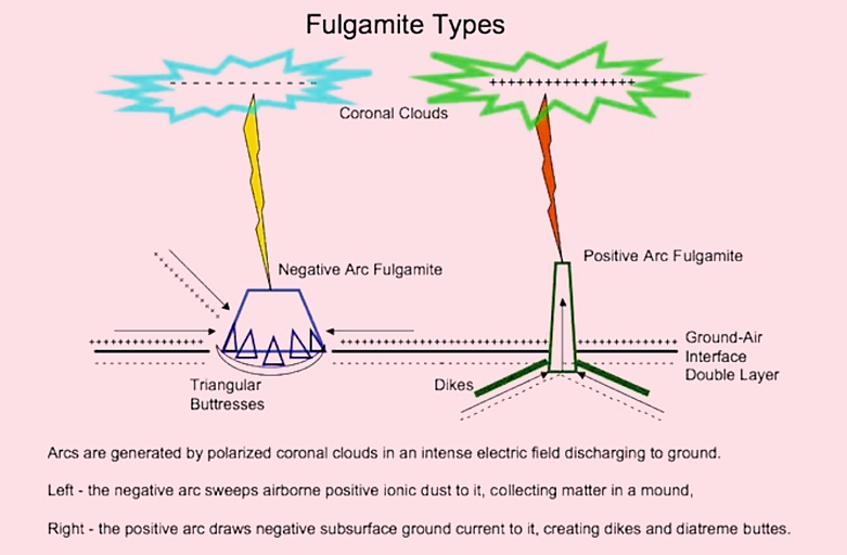 Fulgamite scars on lightning arrestors are bell-shaped with a circular crater, or craters, at the summit. They often rise steeply from a circular depression or ‘borrow pit,’ with many rings. This should sound familiar to any keen observer of Mars. Olympus Mons has all of these strange features, which do not fit the volcano model. The giant volcanoes on Mars are in fact massive fulgamites!” Perhaps all craters are fulgamites with their tops electrically eroded. Depending on the power, an electric arc might leave the fulgamite intact before leaping upward to complete a circuit with whatever it was that initiated the leader stroke. In that instance, there will be no crater on top. The most notable fulgamite found on Earth, is the Brandberg Massif. Elevation 2,573 m (8,442 ft)
Prominence 1,802 m (5,912 ft)
Coordinates: 21°08′57″S, 14°34′39″E .
GAC–Global Area Coverage. GAC data are derived from a sample averaging of the full resolution AVHRR data. Four out of every five samples along the scan line are used to compute one average value and the data from only every third scan line are processed, yielding 1.1 km by 4 km resolution at the subpoint.
GAIN COEFFICIENT – Gain coefficient is a measurement to denote an increase in signal power in transmission from one point to another.
GAMMA – This is a unit of magnetic intensity.
GAMMA-RAY DATA – Gamma-ray data are high frequency, penetrating radiation emitted from the nucleus of a radioactive atom.
GAMMA-RAY SPECTROSCOPY – This non-destructive analytical technique is used to determine concentrations of specific chemical elements such as potassium, thorium, and uranium. These elements have naturally occuring radioactive isotopes based on their normal radioactive decay and the associated emission of gamma-rays at specific wavelengths.
GAUSS-SEIDEL – The Gauss-Seidel method is a technique for interpolating irregularly spaced data points, such as spot elevations, onto a regular grid (e.g., Digital Elevation Models). Unlike simple interpolation methods which assume only correlation, the Gauss-Seidel method is used when some characteristics of the system are known, such as the local value of a derivative. This method, which must be solved iteratively, takes the form of an implicit equation. The Successive Over Relaxation (SOR) method, a refinement to the Gauss-Seidel method, causes the system to converge more rapidly so fewer iterations are required to achieve the same result.
GCP–Ground Control Point. GCPs are physical points on the ground whose positions are known with respect to some horizontal coordinate system and/or vertical datum. When mutually identifiable on the ground and on a map or photographic image, ground control points can be used to establish the exact spatial position and orientation of the image to the ground. Ground control points may be either horizontal control points, vertical control points, or both.
GCTP–General Cartographic Transformation Package. The official U.S. Geological Survey (USGS) map projection software library, the GCTP is a system of software routines designed to permit the transformation of coordinate pairs from one map projection to another. The GCTP is the standard computer software used by the National Mapping Division for map projection computations.
GEODETIC – Of or determined by geodesy; that part of applied mathematics which deals with the determination of the magnitude and figure either of the whole Earth or of a large portion of its surface. Also refers to the exact location points on the Earth’s surface.
GEODETIC ACCURACY – The accuracy with which geographic position and elevation of features on the Earth’s surface are mapped. This accuracy incorporates information in which the size and shape of the Earth has been taken into account.
GEOREGISTERED – An image that has been geographically referenced or rectified to an Earth model, usually to a map projection. Sometimes referred to as geocoded or geometric registration.
GIRAS–Geographic Information Retrieval and Analysis System. GIRAS reflects the judgement of the USGS concerning the presentation and format of polygonal data. The GIRAS data structure was designed to handle large quantities of data for a map area. With the data structure, the basic topological elements (arcs, nodes, and polygons) are all uniquely identified and cross-referenced to one another.
GIS–Geographic Information System. A system, usually computer based, for the input, storage, retrieval, analysis and display of interpreted geographic data. The data base is typically composed of map-like spatial representations, often called coverages or layers. These layers may involve a three-dimensional matrix of time, location, and attribute or activity. A GIS may include digital line graph (DLG) data, digital elevation models (DEM), geographic names, land-use characterizations, land ownership, land cover, registered satellite and/or aerial photography along with any other associated or derived geographic data.
GISS–Goddard Institute of Space Studies. Based out of New York, New York, GISS, one of NASA’s Goddard Space Flight Center research facilities, institutes activities involving research and analysis in specialized subjects, including climate, biogeochemical cycles, remote sensing, and planetary atmospheres.
GLOBAL CHANGE MASTER DIRECTORY – The Master Directory (MD) is an online computer-based system designed to enable rapid identification and location of data of interest to earth and space science researchers. It provides brief, high level data set information from which the user should be able to identify data of potential interest. The Master Directory has remote linking capabilities to a number of other online data directories. The MD resides on a VAX at the National Space Science Data Center (NSSDC) and may be reached from GLIS by selecting the Remote Option (6) on the GLIS Main Menu screen.
GMT–Greenwich Mean Time, the mean solar time of the meridian of Greenwich used as the prime basis of standard time throughout the world.
GNEISS – A name applied to a broad group of rocks. Generally speaking gneisses are banded rocks formed during high-grade regional metamorphism; a metamorphic rock that resembles granite. “Metamorphic rock” is rock that has been changed by heat or pressure. Gneiss is a crystalline rock, consisting, like granite, of quartz, feldspar, and mica, but having these materials, especially the mica, arranged in planes, so that it breaks rather easily into coarse slabs or flags. Hornblende sometimes takes the place of the mica, and it is then called hornblendic gneiss or syenitic gneiss. Similar varieties of related rocks are also called gneiss.
GOAT PADDOCK, AUSTRALIA (impact crater) – This image, taken by the shuttle Large Format Camera, shows the Goat Paddock Crater, which is located within the semi-arid plains south of the Kimberley Plateau of northwestern Australia.
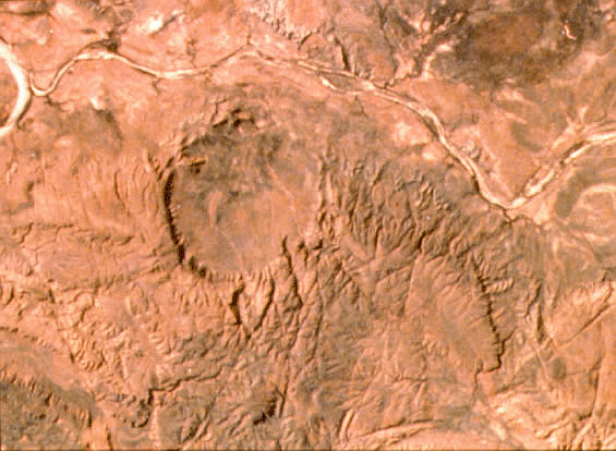
The crater is expressed as a nearly circular depression open to the north. Its name is derived from its natural use as a paddock (a fenced pasture) for livestock. Goat Paddock’s diameter is very close to the transition diameter from simple bowl-shaped craters to more complex forms with central structures, flat floors, and slumped rim zones. Unfortunately, very little is currently known about this potentially instructive feature. (Space shuttle image STS17-4107-1228.) Location: 18°20’S, 126°40’E Diameter: 5.1 kilometers (3.1689930804 miles), Age: <55 million years.
GOSSES BLUFF, Northern Territory, Australia (impact crater) – This highly eroded structure is situated just south of the MacDonnell Ranges (left part of the picture) in the arid Missionary Plain in the Northern Territories, Australia.
Although it could be mistaken for the crater rim, the central ring of hills (5-6 kilometers (3.107 – 3.727 miles) in diameter) results from differential erosion of the central uplift within this large complex crater. The rim itself has been eroded and is no longer visible, but the circular, grayish drainage system outside the inner ring of hills probably marks the original extent of the structure before erosion. North is to the left. (Space shuttle image STS41D-41-028.) Location: 23°50’S, 132°19’E. Original rim diameter: 22 kilometers (13.670 miles). Age: 142.5 ± 0.5.
GPS–Global Positioning System. The GPS is a worldwide satellite navigation system that is funded and supervised by the U.S. Department of Defense. GPS satellites transmit specially coded signals. These signals are processed by a GPS receiver that computes extremely accurate measurements, including 3-dimensional position, velocity, and time on a continuous basis. [Woods Hole Field Center]
GRASS–Geographic Resources Analysis Support System. GRASS is a product of the U.S. Army Corps of Engineers Construction Engineering Research Laboratories (USACERL) in Champaign, Illinois. It is an integrated set of programs designed to provide digitizing, image processing, map production, and geographic information system capabilities to its users.
DISCLAIMER: Any use of trade, product, or firm names is for descriptive purposes only and does not imply endorsement by the U.S. Government.
GRAVIMETRIC – Relating to weight measurement. A GRAVIMETER is an instrument used for determining the specific gravity of bodies, solid or liquid.
GSFC–Goddard Space Flight Center. The NASA GSFC was established in 1959 just northeast of Washington, D.C. Goddard’s mission is to expand knowledge of the Earth, its environment, the solar system and the universe through the development and use of near-Earth orbiting spacecraft. The GSFC is responsible for supporting NASA’s leadership role in space and Earth sciences; research and application of technology for sensors, instruments and information systems; planning and executing space flight projects for scientific research; and for tracking of manned and unmanned Earth satellites through worldwide ground and space communication systems.
GUEST – A GLIS guest user is one who has not registered as a fully functional GLIS user. The guest user has full search capabilities and may request that data be ordered, but does not have the capability to save session information or search results, have a GLIS electronic mailbox, or use some of the system’s advanced features. A guest may register by selecting the USERINFO option from the MAIN_MENU screen. NOTE: A registered user who has signed on as a guest cannot switch to a “registered user” status within the same session. The user must exit GLIS and login as a registered user.
GUYOT – A seamount of volcanic origin (especially in the Pacific Ocean).
GVI–Global Vegetation Index. The GVI is a specific AVHRR application that uses global area coverage (GAC) data to produce a vegetative index called the normalized difference vegetation index (NDVI). GAC data are processed daily and then composited on a weekly basis to produce a global map portraying vegetation vigor.
HASSELBLAD 500 EL/M 70-MM CAMERAS – NASA has modified standard off-the-shelf Hasselblad 70 mm cameras to operate in zero gravity aboard the Space Shuttle. A data recording module (DRM) has also been installed on each camera to record the date, time (Greenwich Mean Time), mission number, roll number, and frame number. The cameras utilize a 70 mm film format and operate with one of three lenses (50, 100, or 250 mm) to acquire high quality photographs through four viewing ports on the Shuttle.
HAUGHTON, CANADA (impact crater) –
Haughton
The Haughton Impact Crater is located on Devon Island, within the arctic archipelago of Canada’s Northwest Territories. Dry summers, harsh winters, and acidic soil conditions inhibit growth of vegetation and make this an ideal location for assessing lithological conditions via satellite image data. This nearly true-color image was generated from the blue, green, and near-infrared bands of the Thematic Mapper and shows the dramatic contrast between the crater breccias (Tib) and the surrounding lower Paleozoic rocks on which the crater was formed. The crater formed in the Allen Bay Formation (OSA) but penetrated and excavated older rocks as deep as 1800 meters (1.118 miles) below the surface. Dramatic north-south-trending bands discriminate various lithological units in the area because this assemblage developed a very slight westward tilt prior to the emplacement of unit K-T sometime during the late Cretaceous or Early Cenozoic Periods. Now the complete sequence is exposed along an east-west traverse; the oldest unit exposed is the Ordovician Bay Fiord Formation (OCB) located to the east of the crater. To the south of the crater, this unit is located 800-1000 meters (874.890 – 1093.613 yards) below the surface but is exposed within the crater due to late-stage uplift accompanying the impact event itself. Younger units observed in this image include the tan-colored carbonates of the Silurian Cape Storm formation (SCS) and overlying, reddish-brown deposits of the Silurian Douro formation (SDO). (Processed Landsat TM Scene No. LT404404; image courtesy of V. L. Sharpton.) Location: 75°22’N, 89°41’W Diameter: 24 kilometers (14.913 miles), Age: 23 ± 1 million years.
HORIZONTAL INTEGRATION – The process of mosaicking adjacent parts of a map or image together into a single map or image. This process might require geometric adjustments to the image itself or the features within it so that matching occurs across mosaic seams.
HORIZONTAL POLARIZATION – Transmission of microwaves so that the electric lines of force are horizontal, while the magnetic lines of force are vertical.
HORIZONTAL POSITIONAL ACCURACY – Horizontal positional accuracy is based upon the use of USGS source quadrangles which are compiled to meet National Map Accuracy Standards (NMAS). NMAS horizontal accuracy requires that at least 90 percent of points tested are within 0.02 inches of the true position. The digital data are estimated to contain a horizontal positional error of less than or equal to 0.003 inches standard error in the two component directions relative to the source quadrangle.
HRPT–High Resolution Picture Transmission. HRPT data are full resolution image data transmitted to a ground station as they are collected. The average instantaneous field-of-view of 1.4 milliradians yields a HRPT ground resolution of approximately 1.1 km at the satellite nadir from the nominal orbit altitude of 833 km (517 mi).
HRV–High Resolution Visible Imaging Instrument. The HRV instrument is a multispectral radiometer designed for SPOT spacecraft. The HRV instrument provides for high-resolution imaging in the visible and near-infrared portions of the electromagnetic spectrum. The first three SPOT satellites carry twin HRVs that operate in a number of viewing configurations and in different spectral modes. Some of those viewing configurations and spectral modes include one HRV only operating in a dual spectral mode (i.e., in both panchromatic mode and multispectral mode); two HRVs operating in the twin-viewing configuration (i.e., one HRV in panchromatic mode and one HRV in multispectral mode); and two HRVs operating independently of each other (i.e., not in twin-viewing configuration).
HYDROLOGY – Scientific study of the waters of the Earth, especially with relation to the effects of precipitation and evaporation upon the occurrence and character of ground water.
HYPERTEXT – The use of links between related words, graphics, or documents that allow the user to jump to associated topics or definitions when reading menus or help files.
HYPSOGRAPHY – The scientific study of the Earth’s topologic configuration above sea level, especially the measurement and mapping of land elevation.
ICOSAHEDRAL PROJECTION – The Dymaxion map or Fuller map is a projection of a world map onto the surface of an icosahedron, which can be unfolded and flattened to two dimensions.
Dymaxion Globe
The flat map preserves shapes and sizes. The projection was invented by Buckminster Fuller. The 1954 version published by Fuller, made with co-cartographer Shoji Sadao, the Airocean World Map, used a modified but mostly regular icosahedron as the base for the projection, which is the version most commonly referred to today. This version depicts the Earth’s continents as “one island”, or nearly contiguous land masses. The Dymaxion projection is intended only for representations of the entire globe. It is not a gnomonic projection, whereby global data expands from the center point of a tangent facet outward to the edges. Instead, each triangle edge of the Dymaxion map matches the scale of a partial great circle on a corresponding globe, and other points within each facet shrink toward its middle, rather than enlarging to the peripheries. A map of the Earth which presents geographic information in a single, comprehensive picture without breaks in any of the continental contours, or any visible distortion of the relative shapes or sizes of the land masses. A world projection with negligible distortion which can accurately display at a glance global information.
I*2 INTEGER – A format of data whose values are represented by 16-bit words. Data distributed as I*2 format can have values ranging between -32,768 to +32,767. This format is commonly used for digital elevation and other data which requires values higher than the 0 to 255 range available for 8-bit (byte) data used for many remote sensing satellite image data. (Note that in computers and online documents, the asterisk is used instead of the ‘x’ to show multiplication. Note further that this is an arbitrary and unnecessary change, since all keyboards and computers that have the symbol ‘*’ available, also have the symbol ‘x’ available, as well. -Ed. )
IFOV–Instantaneous Field-of-View. IFOV is the solid angle through which a detector is sensitive to radiation. In a scanning system this refers to the solid angle subtended by the detector when the scanning motion is stopped. The IFOV is commonly expressed in milliradians.
IMDISP – The IMDISP is an interactive IMage DISPlay utility for personal computers. It can be used to display and manipulate raster images on a PC’s monitor screen, as well as being used to perform basic digital image processing tasks such as histograms and contrast enhancement. When accessing raster images using IMDISP, the program requires the user to supply information about the size, type, and location the image file to be displayed. This information can be entered manually or can be provided in an ASCII label file. This label file can be located at the beginning of an IMDISP formatted image file or can be a separate file that points to the image file. The IMDISP is public domain software developed by Mike Martin at NASA’s Jet Propulsion Laboratory in Pasadena, California, and supported by the NASA Goddard Space Flight Center in Greenbelt, Maryland.
IMPACT CRATERS (geographical repartition of) – Geographic locations of structures that have been confirmed to date (2001) as being of impact origin: Large terrestrial impacts are of greater importance for the geologic history of the Earth than the number and size of preserved structures might suggest. Currently, about 160 structures of impact origin have been confirmed on the Earth’s surface. Precise ages are known for only about one-third of these structures. Crater ages can be determined by a variety of methods. The more precise ones involve radiometric dating of impact melt rocks or impact glasses or bio-stratigraphic dating of related impact ejecta within a well-defined stratigraphic sequence. The paucity of age data reflects not only the lack of detailed studies, but, in many cases, the lack of datable material, especially for deeply eroded or subsurface structures.
IMPACT CRATERS (terrestrial) – Impact craters are formed when a large meteoroid (asteroid or comet) crashes into a larger planetary body that has a solid surface. All the bodies in our solar system have been heavily bombarded by meteoroids throughout their history. The landscapes of the Moon, Mars, and Mercury have conspicuously preserved this bombardment record because the surfaces of these relatively small planetary bodies have remained
unchanged over hundreds of millions of years. Compared to the Moon, the Earth has been even more heavily bombarded over the course of its history due to its stronger gravitational attraction. However, impact craters are not immediately obvious on the surface of Earth because our planet is geologically active; the surface is in a constant state of change from erosion, infilling, volcanism, and tectonic activity. These processes have led to the rapid removal or burial of Earth’s impact structures. Thus, only about 160 terrestrial impact craters have been recognized to date. The majority of them are located within the geologically stable cratons of North America, Europe, southern Africa, and Australia; this is also where most of the crater searches have taken place. Spacecraft orbital imagery and geophysical surveys for resource exploration have helped to identify structures in more remote locations. Impact cratering research has gained attention throughout the world following the suggestion that a large impact event caused the extinction of about 50% of all living species, including the dinosaurs, approximately 65 million years ago. The evidence that a large asteroid or comet struck the Earth at that time came from detailed studies of the thin clay layer that globally marks the stratigraphic boundary between the Cretaceous and Tertiary (K-T) geological periods. This layer is enriched in the siderophile elements (such as iridium), indicating that the clay represents a mixture of normal crustal rocks, which typically have low siderophile-element abundances, and a small percentage of extraterrestrial material. The worldwide integrated volume of the extraterrestrial material in the K-T boundary layer is equivalent to an asteroid approximately 10 kilometers (6.214 miles) in diameter – large enough to have produced a 200-kilometer (124.274 mi)-diameter crater. In the early 1990s, the subsurface Chicxulub structure in Mexico was confirmed as the long-sought Cretaceous-Tertiary boundary impact crater. An environmental crisis, triggered by the gigantic collision, contributed to the extinctions. Based on apparent correspondences between periods observed in the marine extinction record and in the terrestrial impact record, some scientists have suggested that large meteorite impacts might be the metronome that sets the cadence of biological evolution on Earth -an unproved but intriguing hypothesis. Nevertheless, the study of the K-T extinction and its association with one of the largest impact structures known on Earth led to renewed and widespread interest in impacts. The key to understanding the explosive nature of an impact event is the high velocity with which a meteoroid hits the Earth. These velocities range between 11.2 kilometers (6.959 mi) per second (the escape velocity of the Earth-Moon system) and 72 kilometers (44.738 mi) per second (the orbital velocity of the Earth plus the escape velocity of the solar system at the distance of the Earth from the Sun). Because the kinetic energy liberated on impact of an object is proportional to the square of its velocity, these high-speed meteoroids can be, gram for gram, more than 100 times as explosive as TNT! In some cases, nonterrestrial relative abundance of siderophile elements can be detected in the impact melt rocks within large craters (or in impact ejecta, as at the K-T boundary sediments mentioned above); this provides a chemical signature of the meteorite impactor. The most commonly used chemical elements for such studies are the platinum group elements (e.g., iridium, osmium, and platinum). This is based on the fact that almost all meteorites have abundances of these elements that are higher by factors of 20,000 to 100,000 than those of average terrestrial crustal rocks. The addition of even a small meteoritic component (less than 1%) results in distinctly elevated platinum group element contents in the impact breccias or melt rocks. Since the 1960s, numerous studies have documented another physical marker of meteorite impact: shock metamorphism. This refers to metastable or irreversible effects produced in various target rocks and minerals as the strong shock wave passes through them. As hypervelocity impact is the only naturally occurring process capable of generating strong shocks in crustal rocks, certain shock-metamorphic effects are unambiguous signatures of meteorite impact. Diagnostic shock effects include shatter cones, multiple sets of microscopic planar deformation features in quartz, feldspar, and most other rock-forming and accessory minerals, diaplectic glass, and high-pressure mineral phases, such as stishovite (a high-pressure form of quartz). Even diamonds are formed by high-pressure conversion of graphite in target rocks. Researchers have recognized that the presence of shock-metamorphic effects is a much better indicator of the impact origin of a geologic structure than the presence of meteorite fragments (which are rapidly destroyed by erosion anyway). Experimental studies over the past three to four decades have provided a good database that shows which types of shock features form at which pressures. It was also recognized that the effects resulting from shock (nonequilibrium processes) are different from those resulting from static high pressures (an equilibrium process). Today, terrestrial impact structures are confirmed based on the presence of some or all of these shock effects. Impact craters are divided into two main groups, based on their morphology: simple craters and complex craters. Simple craters are relatively small, with depth-to-diameter ratios of about 1:5 to 1:7 and a smooth bowl shape. In larger craters, however, gravity causes the initially steep crater walls to collapse downward and inward, forming a complex structure with a central peak or peak ring and a shallower depth compared to diameter. The diameter at which craters become complex depends on the surface gravity of the planet: The greater the gravity, the smaller the diameter that will produce a complex structure. On Earth, this transition diameter is 2-4 kilometers (1.24 – 2.48 miles) (depending on target rock properties); on the Moon, at one-sixth Earth’s gravity, the transition diameter is 15-20 kilometers (9.32 – 12.42 miles). (Christian Koeberl and Virgil L. Sharpton)
IMPACTOR – An object (such as a meteorite) that collides with another body.
INTERCEPT – Intercept is the distance from the origin to the point at which a curve or line crosses an axis.
INTERPOLATE – To insert a value between known values by using a procedure or algorithm specifically related to the known values.
ISO–International Organization for Standardization. The ISO is a specialized international agency established to maintain standardization. Over 85 countries are participating members. Only one organization from each participating country may be a member. As an example ANSI is the United States member body. Members contribute to technical committees and vote for or against the approval of developed standards.
ISO 9660 – The ISO 9660 standard is the currently accepted industry standard for Compact Disc-Read Only Memory (CD-ROM). This standard assures the generation of CD-ROMs whose format is compatible with a multitude of computer platforms supporting IBM compatible DOS, Apple Macintosh, and Unix operating systems.
ISOMETRIC PROJECTION – A method of drawing figures and maps so that three dimensions are shown not in perspective but in their actual measurements.
ISOPLETH – A line on a map connecting points at which a given variable has a specified constant value.
ISOTOPE — One of two or more variations of the same chemical element, differing in the number of neutrons not the number of protons.
ISOTOPE-DILUTION MASS SPECTROMETRY – This destructive analytical technique is used to determine concentrations of specific chemical elements based on their rates of molecular diffusion in a gaseous or vaporous mixture. A known quantity of the chemical element in question is added to the mixture. This quantity, referred to as a tracer, is monitored to measure its diffusion rate.
ISOTOPIC AGE – Isotopic age, also referred to as radiometric age, is an age of rocks expressed in years and calculated from the quantitative determination of radioactive elements and their decay products.
ITURRALDE, BOLIVIA (impact crater) – The Iturralde Crater (also known as the Araona Structure) is a suspected crater that may have formed in northern Bolivia in the relatively recent geological past.
Iturralde
The feature is believed to have been caused by impact into the muddy alluvial flood plain in the Lower Amazon jungle. The circular depression is now roughly 8 kilometers (4.971 miles) across and 3 meters (3.281 yards) deep. The structure was discovered in Landsat data acquired in 1988, but was not visited successfully until 1998 because the region was inaccessible. Future expeditions hope to finally determine if the feature truly is an impact crater and, if so, constrain the nature of the impactor. (Courtesy of Scientific Visualization Studio, NASA Goddard Space Flight Center.) Location: 12°30’S, 67°30’W Diameter: 8 kilometers (4.971 miles), Age: unknown.
KABIRA CRATER – Largest crater in the Great Sahara desert, was reported in 2006 by Boston University scientists, who claimed a meteorite impact of tens of millions of years ago.
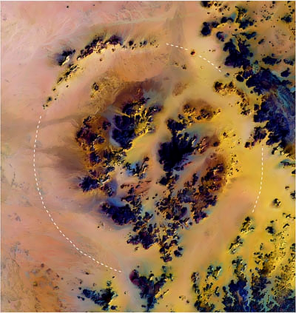
The crater with an outer rim surrounding an inner ring is approximately 31 km (19.262 mi) in diameter, much larger than the next biggest crater of the Sahara in Tchad, 12 km (7.456 mi). The location is on the Southern tip of the Gilfkebir Region in southwestern Egypt. The terrain is of million year old sandstone, typical of Eastern Sahara. The impact may have been responsible for the extensive field of “desert glass,” the yellow grand silica fragments found on the desert surface all over the giant dunes of the Great Sand Sea.
KAME — n. A short, steep-sided knoll of glacial sediment.
KARST — n. A type of topography formed by dissolution of rocks like limestone and gypsum that is characterized by sinkholes, caves, and subterranean passages.
KETTLE LAKES — n. Lakes formed as water fills a hole formerly occupied by a block of stranded ice.
JNC–Jet Navigation Chart. The JNC series provides worldwide coverage at 1:2,000,000 scale. The information on these charts are suitable for aeronautical long-range, high-altitude, high-speed travel; map features include cities, roads, railroads, lakes, principal drainage, and permanent snow/ice areas. The polar regions are in a Transverse Mercator projection. All other regions are presented in the Lambert Conformal Conic projection.
KARA-KUL, TAJIKISTAN (impact crater) – The spectacular Kara-Kul structure is readily apparent in this satellite view.
Kara-kul
Partly filled by the 25-kilometer (15.534 mile)-diameter Kara-Kul Lake, it is located at almost 6000 meters (3.727 miles) above sea level in the Pamir Mountain Range near the Afghan border. Only recently have impact shock features been found in local breccias and cataclastic rocks. (Space shuttle image STS-73-717-60.) Location: 38°57’N, 73°24’E Rim diameter: 52 kilometers (32.311 miles), Age: <10 million years.
KELVIN UNITS – A Kelvin Unit refers to a thermometric scale in which the degree intervals are equal to those of the Celsius scale and in which zero(0) degrees equals -273.15 degrees Celsius (absolute zero).
LAC–Local Area Coverage. LAC are full resolution data that are recorded on an onboard tape recorder for subsequent transmission during a station overpass. The average instantaneous field-of-view of 1.4 milliradians yields a LAC ground resolution of approximately 1.1 km at the satellite nadir from the nominal orbit altitude of 833 km (517 mi).
LAMBERT AZIMUTHAL EQUAL AREA PROJECTION – Azimuthal projections are formed onto a plane which is usually tangent to the globe at either pole, the Equator, or any intermediate point. The Lambert Azimuthal Equal Area projection is a method of projecting maps on which the azimuth or direction from a given central point to any other point is shown correctly and also on which the areas of all regions are shown in the same proportion of their true areas. When a pole is the central point, all meridians are spaced at their true angles and are straight radii of concentric circles that represent the parallels. This projection is frequently used in one of three aspects: The polar aspect is used in atlases for maps of polar regions and of the Northern and Southern Hemispheres; the equatorial aspect is commonly used for atlas maps of the Eastern and Western Hemispheres; and the oblique aspect is used for atlas maps of continents and oceans.
LAMBERT CONFORMAL CONIC PROJECTION – The Lambert Conformal (having correct form or shape) Conic Projection is derived by the projection of lines from the center of the globe onto a simple cone. This cone intersects the Earth along two standard parallels of latitude, both of which are on the same side of the equator. All meridians are converging straight lines that meet at a common point beyond the limits of the map. Parallels are concentric circles whose center is at the intersection point of the meridians. Parallels and meridians cross at right angles, an essential of conformality. To minimize and distribute scale errors, the two standard parallels are chosen to enclose two-thirds of the north to south map area. Between these parallels, the scale will be too small, and beyond them, too large. If the north to south extent of the mapping is limited, maximum scale errors will rarely exceed one percent. Area exaggeration between and near the standard parallels, is very slight; thus, the projection provides good directional and shape relationships for areas having their long axes running in an east to west belt.
LANDSAT (formerly ERTS) – The Landsat program, first known as the Earth Resources Technology Satellite (ERTS) Program, is a development of the National Aeronautics and Space Administration (NASA) in association with NOAA, USGS, and the Space Imaging. The activities of these combined groups led to the concept of dedicated Earth-orbiting satellites, the defining of spectral and spatial requirements for their instruments, and the fostering of research to determine the best means of extracting and using information from the data. The first satellite, ERTS 1, was launched on 7/23/72. The second satellite was launched on 1/22/75. Concurrently the name of the satellites and program was changed to emphasize its prime area of interest (land resources). The first two satellites were designated as Landsats 1 and 2. Landsat 3 was launched on 3/5/78. Landsat 4 was launched on 7/16/82. Landsat 5 (launched 3/1/84) is currently in service providing selected data to worldwide researchers.
LAS–Land Analysis System. The LAS is an image analysis system designed to ingest, manipulate, and analyze digital image data by providing the user with a wide array of functions and statistical tools. LAS supports research and production for remote sensing, image processing, and geographic information systems (GIS). It provides a flexible framework for the processing and the analysis of image data as well as for algorithm development. It is the main software system for the production image processing capabilities at the U.S. Geological Survey’s EROS Data Center (EDC).
LAS HEADER – A LAS image header contains descriptive information about an image file. This header is located in the first 512-byte record of the image file. This information record is mandatory for all LAS images accessed directly from computer or optical disk.
LAVA — Any molten material that is extrusive or volcanic, or the rock that forms from a molten extrusive.
LIGHTNING – Lightning is a large-scale natural spark discharge that occurs within the atmosphere or between the atmosphere and the Earth’s surface. On discharge, a highly electrically conductive plasma channel is created within the air, and when current flows within this channel, it rapidly heats the air up to about 25,000°C (45,032°F). The lightning channel is an example of terrestrial plasma in action. Natural terrestrial plasmas include visual phenomena such as lightning, auroras and red sprites. The existence of plasma discharges from thunderstorms to space, called Sprites, Gnomes and Elves for their brief and ethereal appearance, is a relatively recent scientific discovery. Their genesis, power, and frequency are far from understood. To behave as a plasma, it only takes 1% of neutral air to be ionized. Lightning genesis requires a plasma because that is what forms the “electrode” in the sky. The air is a weak conductor with a variable, vertical current between the ground and the ionosphere of 1 – 3 pico-amps per square meter. The resistance of the atmosphere is 200 ohms. The “clear sky” voltage potential averages 200 to 400-thousand volts between Earth and the upper atmosphere. At any given moment, there are about 2,000 lightning storms occurring worldwide. To create lightning, the electric field potential must overcome the dielectric breakdown of air at 3 million volts per meter. It does so because the electric field in a thunderstorm jumps to over 300-million volts. A typical lightning bolt is three to five miles long and momentarily delivers about 30,000 amps to ground. The collective current from a typical storm delivers from .5 to 1 amp. The circuit is completed — a worldwide current from Earth to the sky, and storms that return it from sky to ground. The 2,000 concurrent lightning storms, each about an amp-and-a-half, means this worldwide current is about 3000 amps. The ground also carries potential that varies. Except for the seismic returns, we can’t even see what is below the Earth’s crust to comprehend the flow of current there. Nor whether, how, or where Earth’s current might enter the atmosphere. For electricity, boundary layers like the Earth’s crust isn’t an impermeable barrier, it’s an electrode. Lightning is visible as a flash of blue-white light. The extremely high temperatures generated heat the air molecules to a state of incandescence (white hot) such that they emit a vivid white light. At the same time, nitrogen gas (the dominant gas in the atmosphere) is stimulated to luminesce, producing bright blue-white. The combination of light from luminescence and incandescence gives the bolt of lightning its characteristic color. Temperatures in the narrow lightning channel reach about 25,000°C (45,032°F). The surrounding air is rapidly heated, causing it to expand violently at a rate faster than the speed of sound, similar to a sonic boom. At about 10 m out from the channel, it becomes an ordinary sound wave called thunder. Thunder is effectively exploding air, and when heard close to the lightning channel, it consists of one large bang. At about 1 km away, it is heard as a rumble with several loud claps. Distant thunder has a characteristic low-pitched rumbling sound. However, beyond 16 km, thunder is seldom heard. There is a “cavity” defined by the surface of the Earth and the inner edge of the ionosphere. It’s been calculated that at any moment, the total charge residing in this cavity is 500,000 coulombs. Electromagnetic waves reflect from the boundary of the cavity — the ground and ionosphere — and establish quasi-standing electromagnetic waves at resonant frequencies. W. O. Schumann predicted the resonant properties of the cavity in 1952, and they were first detected in 1954. They are called Schumann’s resonances and are measured as broadband electromagnetic impulses at frequencies in the range of 5 to 50 Hz. The atmosphere is undeniably electric. It’s not a few ions benignly floating around in the air, occasionally forming into “pools of charge” but a globally active and coherent circuit.
LIMESTONE — A carbonate sedimentary rock composed of more than 50 percent of the mineral calcium carbonate (CaCO3), chiefly formed by accumulation of organic remains.
LEVEL 1b – Level 1b is considered raw quality controlled data configured into discrete data sets and to which Earth location and calibration information have been appended, but not applied.
LFC–Large Format Camera. The LFC was a high altitude aerial mapping camera scaled up to operate from the Space Shuttle in Earth-orbital altitudes. LFC specifications included:
-Film Format Size: 9 x 18 inches (23 x 46 cm) -Lens Aperture: F/6.0 -Lens Focal Length: 12 inches (30.5 cm) -Exposure Interval: 7.5 sec. -Exposure Range: 1/250 to 1/31.25 seconds -Ground Resolution: 20 meters at 160 nautical miles -Ground Coverage: 120 x 240 nautical miles at 160 n.m.
LINHOF AERO TECHNIKA CAMERAS – NASA has modified the Linhof cameras to operate in zero gravity on board the Space Shuttle. The camera utilizes a five-inch film format and is equipped with interchangeable lenses (90 mm and 250 mm). A data recording module (DRM) is also mounted on the camera to record the date, time (Greenwich Mean Time), mission number, roll number, and frame number for each photograph. The Linhof camera is used to acquire earth-looking photography through four viewing ports on board the Shuttle.
LOESS — n. A widespread, loose deposit consisting mainly of silt; most loess deposits formed during the Pleistocene as an accumulation of wind-blown dust carried from deserts, alluvial plains, or glacial deposits.
MAFIC — Term used to describe the amount of dark-colored iron and magnesium minerals in an igneous rock. Complement of felsic.
MAGMA — n. Molten rock generated within the Earth; forms intrusive (solidifies below the surface) and extrusive (solidifies above the surface) igneous rocks.
MAGNETITE – a black to brownish metallic stone (iron oxyde) with magnetic properties. The legendary lodestone is one of the magnetites. The magnetites are formed of octahedral crystals of mineral whose chemical structure contains
the unit, XFe 2 0 4 . X may be Fe, Mg, Ni, Zn, or Mn. The first is most
common; the last two are only weakly magnetic.
MAGNETOTELLURICS (MT) – Dissected, the word “magnetotellurics” has two parts – “magneto” for magnetic and “telluric” for earth currents. MT is a geophysical method that measures naturally occurring, time-varying magnetic and electric fields that are found in the earth. From these measurements we can derive resistivity estimates of the subsurface, from the very near surface to tens of thousands of feet. The MT signal is caused by two things: (1) in the lower frequencies (generally less than 1 Hertz, or 1 cycle per second), the source of the signal is interaction of the solar wind with the earth’s magnetic field. As solar storms emit streams of ions, this energy disturbs the earth’s magnetic field and causes low-frequency energy to penetrate the earth’s surface. (2) The higher frequency signal (greater than 1 Hertz) is created by world-wide thunderstorms, usually near the equator. The energy created by these electrical storms travels around the earth (in a wave guide between the earth’s surface and the ionosphere), with some of the energy penetrating into the earth. Both of these sources of signal create time-varying electromagnetic waves. Although these electric and magnetic fields are small, they are measurable. That’s the good news. The bad news is that these signals vary in strength over hours, days, weeks and even over the sunspot cycle (which is about 11 years and creates an increase in the number of solar storms). So, geophysicists measuring MT have to measure for hours at each station in order to get enough signal to ensure high-quality data. This is especially true when measuring them at the lowest frequencies (about 0.001 Hertz, or 1 cycle per 1000 seconds). At these low frequencies, we need to record for 16 minutes to get one sample of data! That means we really need to record for several hours just to get a decent statistical average of good data. Magnetotellurics is based on the simultaneous measurement of total electromagnetic field, i.e. time variation of both magnetic field B(t) and induced electric field E(t). The electrical properties (e.g. electrical conductivity) of the underlying material can be determined from the relationship between the components of the measured electric (E) and magnetic field (B) variations, or transfer functions: The horizontal electric (Ex and Ey) and horizontal (Bx and By) and vertical (Bz) magnetic field components. According to the property of electromagnetic waves in the conductors, the penetration of electromagnetic wave depends on the oscillation frequency. The frequency of the electromagnetic fields development of the theory determines the depth of penetration.
MANICOUAGAN, Quebec, Canada – The Manicouagan impact structure is one of the largest impact craters currently known on the surface of Earth.
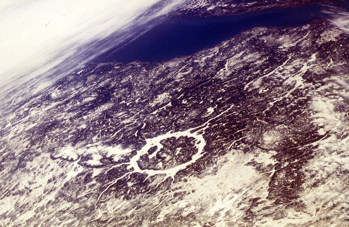
This shuttle oblique view looking south shows the prominent 70-kilometer (43.496 mile)-diameter, ice-covered annular lake that fills a ring where impact-brecciated rock has been eroded by glaciation. The lake surrounds the more erosion-resistant melt sheet created by impact into metamorphic and igneous rock types. Shock-metamorphic effects are abundant in the target rocks of the crater floor. Although the original rim has been removed, the distribution of shock-metamorphic effects and morphological comparisons with other impact structures indicate an original rim diameter of approximately 100 kilometers (62.136 miles). (Space shuttle image STS51B-43-060.) Location: 51°23’N, 68°42’W. Original rim diameter: ~100 kilometers (~62 miles). Age: 214 ± 1 million years.
The moderately eroded, central part of the structure (the plateau surrounded by the lake) is partly covered by impact melts and contains shattered rocks and several uplifted peaks about 5 kilometers (3.11 miles) north of the center.
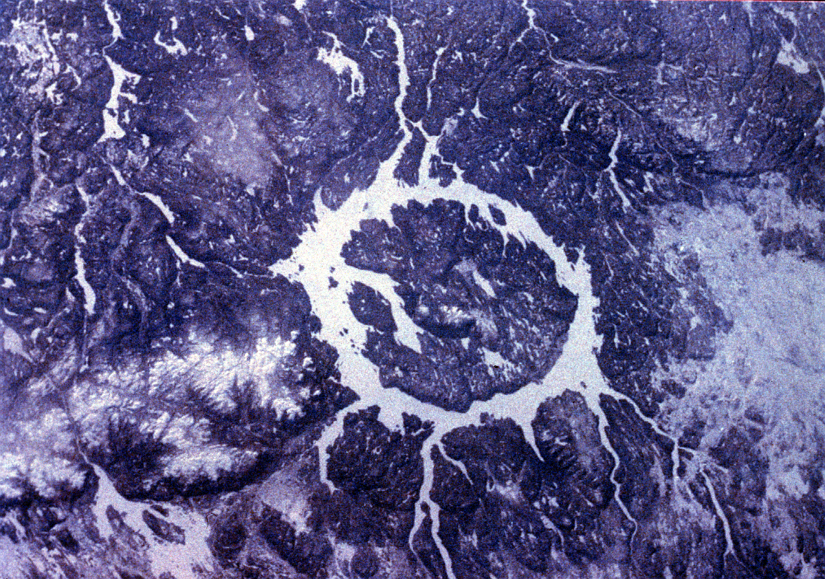
The quantity of data obtained on the melt sheet and the underlying target rocks make Manicouagan one of the most intensely studied large complex impact structure in the world, and it is an important source of ground-truth data for understanding the cratering process. The radiometrically determined age of the structure is close to (but not quite identical with) the biostratigraphically derived age of the Triassic-Jurassic boundary. (Space shuttle image STS42-207-14.)
MARL — n. A loose, crumbly deposit consisting of clay and calcium carbonate and formed in marine or freshwater conditions.
MELANGE — A body of rocks consisting of large blocks (‘mappable’ size) of different rocks jumbled together with little continuity of contacts.
MASCON – A region on the moon (or other body) that has a greater density rock than the surrounding area, and hence has a locally larger gravitational field.
MEAN EARTH-SUN DISTANCE – Mean Earth-Sun distance is the arithmetical mean of the maximum and minimum distances between a planet (Earth) and the object about which it revolves (Sun).
MERCATOR PROJECTION – Mercator is a conformal map projection, that is, it preserves angular relationships. Mercator was designed and is recommended for navigational use and is the standard for marine charts. Mercator is often and inappropriately used as a world map projection in atlases and for wall charts where it presents a misleading view of the world because of the excessive distortion of area in the higher latitude areas.
METEOR CRATER – Arizona – also known as Barringer Crater.
Barringer
With a diameter of approximately 1.2 kilometers (~ 0.74 mi), was the first terrestrial impact crater to be recognized as such. Its impact origin was first suspected late in the nineteenth century, when abundant iron meteorite fragments were discovered in the immediate vicinity of the crater. This finding led the mining engineer Daniel Moreau Barringer to embark, between about 1905 and 1928, on a drilling project to find a suspected large iron meteorite body underneath the crater floor. At this time, however researchers did not yet have a clear understanding of the immense energy that is liberated when an extraterrestrial body hits the surface of the Earth with cosmic velocity. It was only in the 1920s that the first quantitative studies revealed the explosive nature of meteorite impact. Under impact conditions, tremendous amounts of energy are released instantaneously, completely destroying the cosmic projectile and generating a crater that is many times larger than the original meteoroid. In the case of Meteor Crater, an iron meteorite body only about 30-50 meters (~32. to ~54. yards) in diameter was sufficient to create a crater 1.2 kilometers (0.745 mi) in diameter. After the first studies on Meteor Crater, several other relatively small craters were also found to contain impactor fragments, and for many years these remnants were the only accepted evidence for impact origin. But because the projectile does not survive intact in large impact events, scientists have developed more sophisticated means of detecting the signatures of meteorite impact. (Christian Koeberl and Virgil L. Sharpton).
METEORITE – an extraterrestrial rock that has fallen to Earth. Most meteorites are pieces of asteroids and are of stony, stony-iron, or iron composition.
MICROMETERS – A unit of length equal to one-millionth of a meter. It also is referred to as a micron.
MICRONESIA – Micronesia is comprised of Pacific island groupings located at 9.30 degrees north latitude and 143.00 degrees east longitude with a total land area of approximately 700 square kilometers. The Federated States of Micronesia include Kosrae, Pohnpei, Truk, and Yap.
MICROWAVE – The subset of the Electromagnetic Spectrum encompassing wavelengths between .03 and 30 centimeters, corresponding to frequencies of 1-100 gigahertz.
MILLIRADIANS – Unit of angular measure equal to one-thousandth the angle subtended at the center of a circle by an area of length equal to the radius of the circle.
MMSP–Modular Multi-Satellite Preprocessor. The MMSP is a frame synchronizer designed to provide the interface between bit synchronized Landsat thematic mapper telemetry data and the host computer system. It is used as the front end for a Landsat data acquisition system that accepts raw serial telemetry data from high density tape (HDT), frame aligns, samples user specified fields, and presents these data to the host computer for decommutation and image extraction.
MODE – That value that occurs most frequently within the data sample being taken. In a histogram, it is the data value at which the peak of the distribution curve occurs.
MODULATION – The process by which some characteristics of one carrier wave are varied in relation to another wave or signal.
MOHOROVIčIć (MOHO) DISCONTINUITY – is the junction which separates the Earth’s crust and mantle. Its depth is about 10 kilometres (6.214 mi) below the ocean basin. Discovered in 1909 by Andrija Mohorovičić, a Yugoslav geophysicist (Volosko, 1857 – Zagreb 1939).
MORAINE — n. A mound or ridge of sediment deposited by a glacier; lateral moraine- n. deposited to the side of a glacier; terminal moraine- n. deposited to the front of a glacier; ground moraine- n. deposited on the land surface.
MOSS–Map Overlay Statistical System. The MOSS is a vector based GIS system that was first implemented in 1977 by the U.S. Bureau of Land Management.
MSS–Multispectral Scanner. The MSS is a nonphotographic imaging system which utilizes an oscillating mirror and fiber optic sensor array. The mirror sweeps from side to side, transmitting incoming energy to a detector array which sequentially outputs brightness values (signal strengths) for successive pixels, one swath at a time. The forward motion of the sensor platform carries the instrument to a position along its path where an adjacent swath can be imaged. The MSS simultaneously senses radiation using an array of six detectors in each of four spectral bands from 0.5 to 1.1 micrometers.
MULTISPECTRAL – The use of one or more sensors to obtain imagery from different portions of the electromagnetic spectrum.
NAD27–North American Datum of 1927. NAD27 is defined with an initial point at Meads Ranch, Kansas, and by the parameters of the Clarke 1866 ellipsoid. The location of features on USGS topographic maps, including the definition of 7.5-minute quadrangle corners, are referenced to the NAD27.
NAD83–North American Datum of 1983. NAD83 is an Earth-centered datum and uses the Geodetic Reference System 1980 (GRS 80) ellipsoid, unlike NAD27, which is based on an initial point (Meades Ranch, Kansas). Using recent measurements with modern geodetic, gravimetric, astrodynamic, and astronomic instruments, the GRS 80 ellipsoid has been defined as a best fit to the worldwide geoid. Because the NAD83 surface deviates from the NAD27 surface, the position of a point based on the two reference datums will be different.
NADIR – Point on the ground vertically beneath the center of a remote sensing platform.
NAPP–National Aerial Photography Program. NAPP was established to coordinate the collection of aerial photography covering the 48 contiguous States and Hawaii every five years. NAPP’s goals are to ensure that photography with uniform scale, quality, and cloud-free coverage be made available to meet the requirements of several Federal and State agencies. The program was initiated in 1980 as the National High Altitude Photography (NHAP) program. In 1987, the program was renamed to NAPP when the flying height for the program changed from 40,000 feet to 20,000 feet. NAPP photography is available in black and white, and in most cases, color-infrared. The program is administered by the U.S. Geological Survey’s National Mapping Division. NAPP imagery is used by the USGS for photo revision and land use land cover characterization work on the standard series maps at 1:24,000; 1:100,000 and 1:250,000 scales.
NASA–National Aeronautics and Space Administration. The NASA was formed during the administration of President Dwight D. Eisenhower as a response by the President and the United States Congress to achievements in space by the then Union of Soviet Socialist Republics (USSR) including Sputnik I and II. Emphasis was placed on consolidating projects, facilities, and personnel into a national program including the National Advisory Committee for Aeronautics (NACA) which would later become the nucleus for the NASA. The NASA researches solutions to flight problems within and outside of the Earth’s atmosphere. The NASA also develops, constructs, tests, and operates aeronautical and space vehicles. These vehicles, both manned and unmanned, are part of the NASA’s research activities in the exploration of space. In addition, the NASA coordinates the scientific and engineering resources of the United States with other nations engaged in aeronautical and space activities for peaceful purposes.
NASA/ARC–National Aeronautics and Space Administration/Ames Research Center. The ARC’s two installations are located at Moffett Field, California, and at the Dryden Flight Research Facility in Edwards, California. The ARC is responsible for managing a diverse series of research and technology development programs in support of NASA activities including flight simulation and research; aerospace and human factors; atmospheric and Earth sciences applications; and space biology and medicine. The ARC also is responsible for maintaining research and test facilities and equipment including wind tunnels, simulators, supercomputers, and aircraft.
NASA/JSC–National Aeronautics and Space Administration/Johnson Space Center. NASA/JSC or JSC supports the acquisition of Earth observations photography by training the astronauts in Earth science and providing real-time mission support to make the crew aware of photo opportunities during the flight (i.e, hurricanes, fires, floods, volcanoes, ice flows, etc.). JSC also trains the crew to use the camera systems and the techniques needed to acquire high quality photography of Earth and environmental phenomena. After each mission JSC catalogs the acquired photography and enters new records into the Space Shuttle Earth Observation Program (SSEOP) data base. This data base is accessible from GLIS through the use of the REMOTE MENU option.
NATIONAL ATLAS – The National Atlas of the United States of America is a bound collection of full-color maps and charts showing physical features such as landforms, geology, soil, vegetation, and climate. It is produced by the U.S. Geological Survey’s Topographic Division in cooperation with other Federal agencies and private organizations. Economic, social, and cultural information is also presented. All maps of the United States contained in the National Atlas are based on the Albers equal area projection.
NATIONAL GEODETIC VERTICAL DATUM OF 1929 – Reference surface established by the U.S. Coast and Geodetic Survey in 1929 as the datum to which relief features and elevation data are referenced in the conterminous United States; formerly called “mean sea level 1929.”
NATIONAL MAP ACCURACY STANDARDS – Specifications promulgated by the U.S. Office of Management and Budget to govern accuracy of topographic and other maps produced by Federal agencies.
NATSGO–National Soil Geographic. The NATSGO data base is used primarily for national and regional resource appraisal, planning, and monitoring. The boundaries of the Major Land Resource Areas (MLRA) and regions were used to form the NATSGO data base.
NATURAL GAMMA – This is a technique of examining the total gamma radiation of rocks in a drilled hole.
NCAR–National Center for Atmospheric Research. The NCAR, in Boulder, Colorado, performs research related to atmospheric problems. NCAR provides service to the university research community and conducts research toward achieving a better understanding of the overall behavior of the atmosphere, including analyzing and predicting atmospheric behavior, establishing solar terrestrial connections, understanding air chemistry and climate, evaluating environmental and societal effects, and studying connective storms and severe weather.
NCDS–NASA Climate Data System. The NCDS is an interactive scientific information management system that allows researchers to locate, access, manipulate, and display a wide variety of climate data. This data can be analyzed on the NCDS host computer or downloaded to other computers for additional analysis. The NCDS library includes many data sets from NASA satellites and various conventional data base sources. This system is located at the Goddard Space Flight Center in Greenbelt, Maryland.
NCSS–National Cooperative Soil Survey. The NCSS is a joint effort of the United States Department of Agriculture and agencies of the States, usually the Agriculture Experiment Stations. In some surveys, other Federal and local agencies also contribute. The Natural Resources Conservation Service (NRCS) has leadership for the Federal part of the NCSS.
NDCDB–National Digital Cartographic Data Base. The NDCDB is a collection of the digital cartographic/geographic data files produced by the U.S. Geological Survey (USGS) as part of the National Mapping Division (NMD). The NDCDB contains elevation data, planemetric data, and landuse and landcover data in various map scales. The digital data are useful for the production of cartographic products such as plotting base maps and for various kinds of spatial analysis. A major use of these digital cartographic/geographic data is to combine them with other geographically referenced data, enabling scientists to conduct automated analyses in support of various decision making processes.
NDVI–Normalized Difference Vegetation Index. The NDVI is computed by calculating the ratio of the VI (vegetation index, i.e., the difference between Channel 2 and 1) and the sum of Channels 2 and 1. Thus NDVI = (channel 2 – channel 1) / (channel 2 + channel 1).
NEATLINES – Neatlines separate the body of a map from the map margin. On quadrangle maps, the neatlines are often the meridians and parallels that delimit the quadrangle.
NESDIS–National Environmental Satellite, Data and Information Service. NESDIS is the element in NOAA that is responsible for establishing a digital archive of data collected from the current generation of NOAA operational polar orbiting satellites.
NEW QUEBEC, Quebec, Canada (impact crater) – This aerial view looks west over the 250-meter (820.210 foot)-deep circular lake that fills the New Quebec Crater, a relatively large, well-preserved crater.
New Quebec
The interior topography of the crater is covered by lake sediments that inhibit a determination of whether the structure has a small central uplift. The rocks involved in this impact event are ancient and strongly deformed gneisses of the Precambrian shield. The jumbled and outwardly tilted rocks comprising the rim extend as much as 160 meters (524.933 feet) above the surrounding countryside, based on its morphological similarity to Meteor Crater in Arizona. This was confirmed much later when diagnostic evidence of shock metamorphism was discovered in the minerals from gneiss samples collected from within the crater. Whereas the ejecta blanket has been removed by erosion, some isolated melt rocks have been found up to 2 kilometers (1.243 miles) from the crater rim.
(Image courtesy of George Burnside, Manotik, Ontario, Canada.)
Location: 61°17’N, 73°40’W. Rim diameter: 3.4 kilometers (2.113 miles). Age: 1.4 ± 0.1 million years.
NGDC–National Geophysical Data Center. The NGDC at Boulder, Colorado, was created in 1965. It is one of three data and information centers of NOAA’s National Environmental Satellite, Data and Information Service (NESDIS). NGDC brings together in one data center activities in solar-terrestrial physics, marine geology/geophysics, and solid earth geophysics.
NIMA–National Imagery Mapping Agency. Activities formerly part of Combat Support Center (see DMA).
NIMBUS – The Nimbus satellite program, initiated by the National Aeronautics and Space Administration (NASA) and later operated by both NASA and the National and Oceanic Atmospheric Administration (NOAA), was developed in the early 1960s to meet research and development needs of the atmospheric and Earth scientists, providing global surveillance of the atmospheric structure at low Earth orbital altitudes for the world’s weather services.
NN–Nearest Neighbor Resampling. When correcting image data points, the nearest neighbor technique assigns for each new pixel that pixel value which is closest in relative location to the newly computed pixel location.
NOAA–National Oceanic and Atmospheric Administration. The NOAA, under the Department of Commerce, operates the civil polar-orbiting and geo-stationary satellite systems for the collection of atmospheric and environmental data.
NPS–National Park Service, Department of the Interior. In 1916, Congress enacted the establishment of the NPS to provide unified administration of parks and monuments. The NPS manages a diverse system of entities including parks, monuments, historic sites, battlefields, seashores, lakeshores, and recreation areas. The NPS also directs programs to assist other Federal agencies, State and local governments, and individuals in the protection of architectural, archeological, historical, and natural resources that are not part of the National Park System.
NRCS–Natural Resources Conservation Service. The U.S. Department of Agriculture’s Natural Resources Conservation Service (NRCS) provides leadership and administers programs to help people conserve, improve, and sustain natural resources and the environment. NRCS’ work covers three major areas: soil and water conservation, natural resource surveys, and community resource protection and management. Prior to 1995, NRCS was known as the SCS (Soil Conservation Service).
NSDI–National Spatial Data Infrastructure. Executive Order 12906, “Coordinating Geographic Data Acquisition and Access: The National Spatial Data Infrastructure,” was signed on April 11, 1994, by President William Clinton. Under this order, each Federal agency is to document all new geospatial data it collects or produces, either directly or indirectly, using the standard developed by the Federal Geographic Data Committee (FGDC) and make that documentation electronically accessible to the Clearinghouse network.
OBLIQUE – An image taken with a camera or sensor with the axis intentionally directed between the vertical and horizontal planes. A high oblique image includes the horizon in the field of view, while a low oblique shows only the Earth’s surface.
ONC–Operational Navigation Chart. The ONC series covers most of the world landmass areas at 1:1,000,000 scale. At this scale it takes 62 charts to cover the conterminous United States. Information on these charts includes cities and landmarks, drainage, and relief (shown by shading and contours). International and State boundaries are shown, but not county boundaries.
ORNL–Oak Ridge National Laboratory. ORNL, under the Department of Energy’s Environmental Science Division and host to the Carbon Dioxide Information Analysis Center, is located in Oak Ridge, Tennessee. Approximately 15,000 research scientists are working on projects sponsored by the Department of Energy, Environmental Protection Agency, Federal Regulatory Commission, and other Government offices. Research activities focus on the variety of unique aspects relating to global change and energy concerns.
ORTHO-CORRECTION – Correction applied to satellite imagery to account for terrain-induced distortion.
OUARKZIZ, Algeria (impact crater) – This structure is situated in sedimentary rocks in the rocky desert of northwest Algeria.
Ouarkziz
It displays a well-defined ring that is partly open to the south. The impact origin is suggested from the occurrence of planar deformation features within rocks returned 30 years ago from the only geologic expedition ever to visit the structure. (Space shuttle image STS41C-31-1032.) (Location: 29°00’N, 07°33’W. Rim diameter: 4 kilometers (2.485 miles). Age: <70 million years.)
OVERSHOOT – That portion of an arc (line) digitized past its intersection with another arc. See dangling arc.
PARSE – To break down a sequence of letters or numbers into meaningful parts based on their location in the character sequence. For example, the first three numbers in the GLIS access phone number 6055946888 are the area code numbers that identify the phone number as a South Dakota location.
PC WORK STATION – As defined by GLIS, a PC work station is a 80286 or greater AT micro computer running the MS-DOS operating system version 3.0 or higher. The PC should have 640 kilobytes of computer memory and have a VGA 16 color 4 bit graphics board and color monitor. To allow connection with the GLIS server the PC work station should have a Hayes or Hayes compatible modem and some type of PC communication package. The PC should also have at least 1 megabyte of hard disk space for GLIS software and data files. Optional GLIS PC work station requirements include a mouse, math co-processor, and dot matrix or laser printer.
PENEPLAIN – a more or less level land surface representing an advanced stage of erosion undisturbed by crustal movements.
PERMAFROST – A permanently frozen layer at variable depth below the surface in frigid regions of a planet (as Earth).
PHANEROZOIC — n. The geologic eon that includes the interval of time from approximately 543 million years (c) ago to the present, comprising the Paleozoic, Mesozoic, and Cenozoic eras.
PHENOLOGY or PHENOLOGICAL – Refers to the rate and timing of natural events, such as the growth cycle of vegetation over a growing. Land cover and vegetation types may often be distinguished from each other by their characteristic spectral/temporal signature, as illustrated by a graph plotting NDVI values against time through a growing season for several agricultural categories. The shape and position of each curve defines that category’s phenological characteristics.
PHYSIOGNOMIC – The aspect and character of an abstract entity.
PIXEL – An abbreviation of picture element. The minimum size area on the ground detectable by a remote sensing device. The size varies depending on the type of sensor.
PLANAR DEFORMATION FEATURES – microscopic features in grains of (for example) quartz or feldspar consisting of very narrow planes of glassy material arranged in parallel sets that have distinct orientations with respect to the grain’s crystal structure.
PLANCK’S – Early in the twentieth century, Max Planck recognized the discrete nature of radiant energy exchanges and proposed the quantum theory of electromagnetic radiation. His experiments showed that energy is transferred in short wave trains or bursts in which each burst carries radiant energy, Q, proportional to the frequency, of the wave, so that: Q = hv where h = the universal, or Planck’s constant, with a value of 6.625 X 10 to the -34 joule second. (A joule, in physics, is a unit of work equal to 10 million ergs.)
PLANIMETRIC – Two dimensional. The measurement of plane surfaces. A map representing only horizontal features. Parts of a map that represent everything except relief.
PLASMOID – A plasmoid is a coherent structure of plasma and magnetic fields. Plasmoids have been proposed to explain natural phenomena such as ball lightning, magnetic bubbles in the magnetosphere, and objects in cometary tails, in the solar wind, in the solar atmosphere, and in the heliospheric current sheet. Plasmoids produced in the laboratory include field-reversed configurations, spheromaks, and the dense plasma focus. Plasmoids appear to be plasma cylinders elongated in the direction of the magnetic field. Plasmoids possess a measurable magnetic moment, a measurable translational speed, a transverse electric field, and a measurable size. There is some scant evidence to support the hypothesis that they undergo fission and possess spin. Plasmoids are astrophysical phenomena, pairs of plasmoids fired from a plasma gun (dense plasma focus device) interact in such a way as to simulate galaxy formation. It is confirmed that the movement of electric charges in plasma forms electromagnetic fields that constrict the current. The constricted channel is known as a “Bennett pinch,” or “z-pinch.” They create electromagnetic structures called “plasmoids”.
PLATE TECTONICs – refers to the folding and faulting of rock and flow of molten lava involving lithospheric plates in the earth’s crust and upper mantle.
PLDS–Pilot Land Data System. The PLDS is a data and information management system developed to support land science research activities by archiving, retrieving, and transferring land data. The PLDS program, sponsored by the Communication and Information Systems Office, Land Processes Branch within the Office of Space Science and Applications of NASA, is managed by Goddard Space Flight Center with active participants at Ames Research Center (ARC) and the Jet Propulsion Laboratory (JPL).
PLSS–PUBLIC LAND SURVEY SYSTEM. The U.S. Public Land Survey System is the most widespread land ownership system in the United States. Roads, fields and political boundaries all reflect the character of a square grid system or more commonly the Township and Range System.
PLUTON — n. Any body of igneous rock that solidified below the earth’s surface.
PLUTONIC — Applies to igneous rocks formed beneath the surface of the Earth; typically with large crystals due to the slowness of cooling. Synonym of intrusive. Antonym of volcanic
POES–Polar Orbiting Environmental Satellite. The POES system began in 1960 with the launch of TIROS-1. Later satellites in the Improved TIROS Operational Satellite (ITOS) program were expanded to capture concurrent multiple-channel data on a daily basis. Currently the Advanced TIROS-N satellites (renamed NOAA-6, 7, 8, etc., after launch) offer 4 or 5 channel multispectral daily repetitive global coverage.
PRECISION – Precision is a statistical measurement of repeatability that is usually expressed as a variance or standard deviation, root mean square or RMS, of repeated measurements. These are expressed as x,y coordinates of arcs, label points, and tics in either single or double precision in ARC/INFO.
Single-precision coordinates have up to seven significant digits of precision. This allows for a level of accuracy of approximately 10 meters for a region whose extent is 1,000,000 meters across. Double-precision coordinates have up to 15 significant digits; this allows for the precision necessary to represent any desired map accuracy at a global scale.
PROFILE – One method of making Digital Elevation Models (DEMs) is commonly referred to as profiling. In this technique a stereo pair of photographs is set up in a photogrammetric instrument and referenced to the ground using ground control points. After this process is completed the instrument automatically moves a computer cursor across the stereo model. As the cursor is being driven across the model, the operator controls the motion of the cursor while a recording device captures the elevation figures. Each swath across the stereo model is called a profile.
PROJECTION – Orderly system of lines on a plane representing a corresponding system of imaginary lines on an adopted terrestrial or celestial datum surface. Also, the mathematical concept of such a system. For maps of the Earth, a projection consists of (1) a graticule of lines representing parallels of latitude and meridians of longitude or (2) a grid.
PROXIMAL EJECTA – all ejecta that are found up to 5 crater radii from the rim of the impact crater; 90% of all ejecta are found within this region. Note that the limit of proximal ejecta scales with the crater size. Ejecta found at greater distances are called distal ejecta.
QUANTAVOLUTION – is an abrupt, large-scale change caused by, and affecting one or more spheres such as the astrophere, biosphere, lithosphere, atmosphere, and anthrosphere.
QUANTIZE – To limit the possible values of (e.g., quantity) to a discrete set of values by quantum mechanical rules (Webster’s II, 1994).
QUAKESAT – Quakesat from the Space Systems Development Laboratory at Stanford University. The satellite transmits on 436.675 MHz and has the amateur radio callsign KD7OVB. CubeSats are called nanosats or picosats because they measure a tiny 4x4x4 inches. QuakeSat was a triple CubeSat because it measured 4x4x12 inches. The satellite was designed to collect from space the extremely low frequency (ELF) radio signals that are earthquake precursors. QuakeSat had to BE large enough to include a one-foot-long magnetometer that extended on a telescoping boom. The receiver was provided by QuakeFinder. It was one of the six CubeSats launched on June 30, 2003, on one ROCKOT booster from the Plesetsk Cosmodrome in Northern Russia to 510-mile-high, sun-synchronous orbits. More info.
RADAR ALTIMETER – Instrument for measuring altitudes or elevations with respect to a reference level, usually mean sea level. A radar altimeter determines the height of an aircraft above the terrain by measuring the time required for an electromagnetic pulse to travel from aircraft to the ground and back again.
RADIAN – A radian is a unit of angular measure equal to the angle subtended at the center of a circle by an arc of length equal to the radius of the circle equal to approximately 57 degrees, 17 minutes, 44.6 seconds.
RADIANCE – Measure of the energy radiated by an object. In general, radiance is a function of viewing angle and spectral wavelength and is expressed as energy per solid angle.
RADIO-CARBON DATING — Method for determining the age of an organic substance by measuring the amount of the carbon isotope, carbon-14, remaining in the substance; useful for determining ages in the range of 500 to 70,000 years. The quantavolutionary hypothesis is disruptive of carbondating, as it has been conceived. An adjusted curve is impossible because the revolutions of the atmosphere in precisely the most critical millenia in primevalogy cannot be positioned and defined sufficiently well for them to be employed in weighing the scale intervals. The 14C method will be useful for dating the past 2,400 years, when allowances are made for short-term atmospheric fluxes owing to extraordinary cosmic, volcanic, solar, industrial, nuclear explosional, or other activity disturbing to the atmosphere. There are many anomalies in C14 dating, a few of which are mentioned elsewhere in this book. Artifact dating has become quite common, with most of the apparent successes occurring on artifacts and substances of the recent historical past. But it is precisely the problem of C14 dating that, by our theory, it is almost surely wrong in the earlier periods when the tests are most needed. A group of scientists recently excavated “Little Salt Spring, Florida: A Unique Underwater Site.” Among many remains they found in a lower level a tortoise carapace, which provided a date of 13,450 ± 190 B.P., and a wood stake used to pry open the animal, which gave a date of 12,030 ± 200. Some 1400 years of difference. Yet this is not the only problem. The whole range of time may be in question. For a base of a carved oak mortar was discovered and dated to 9080 B.P. and then declared to be similar in style to a piece recovered at Key Marco, 130 km to the South, and dated at about 1200 years ago. Mysteriously, corroboration of some of our conclusions comes from a retrogressive calculation by Melvin Cook of the amount of 14C in the ancient atmosphere. Granted the present level of carbon-14 and the fact that it is rising slightly, he found that all the 14C would have had to arrive in the atmosphere within the past ten to twelve thousand years. Far from being constant, prior radio-carbon was at this point wiped out statistically and theoretically a new atmospheric accumulation began. This would appear to be about the time of the climactic Lunarian catastrophe. However, this calculation, as Dr. Cook might grant is more useful as a reductio ad absurdum than as a plotting of the true history of atmospheric carbon. Certain elements, such as potassium-40 and uranium-238, which are to be found in rocks of the crust of the Earth, especially at or near surface levels, are radioactive. They are sometimes called “parent elements” insofar as they decay into “daughter” elements by giving up electrons or by other means. They began their decay as soon as they were formed. One calculates their life-span by figuring backwards from today’s rate of decay as witnessed in a sample of the element. A rock matrix presumably will contain the parent element and the daughter element in proportion to its age, unless it had undergone some exceptional experience. The dozen or so transformations used for dating purposes include uranium-238 decaying into lead-206, of potassium-40 decaying into argon-40, and of rubidium-87 decaying into strontium-87. None of these methods is useful directly for the period since 14,000 B.P. because the decay into daughter elements is too slow to detect over the short time. However, radiodating challenges our model of quantavolution indirectly when it produces long-term dates where short-term dates are expected. For example if, by potassium-40 argon-40 dating, the ocean floor appears to be 100 to 200 million years old, then it cannot have been formed between 13,000 B.P. and 9,000 B.P. Also, when igneous rocks associated with hominid bones of the Olduvai gorge, dated by the same technique, produce an age of about 1.75 million years, then the bones cannot be of the holocene epoch. Radioactivity was discovered a century ago but time-measures of radioactivity are largely a post-World War II development. Despite the shortness of its life, changes in the field have been numerous and radical. Its leaders turn quickly in new directions whenever problems are encountered, introducing new half-lives, slicing experimental rocks differently, and giving their favor now to one, and again to another technique. Major problems occur with radiodating. One is in the setting of a rate of decay and therefore setting a date for “time zero” within a reasonable margin of error. Regarding the “time zero” problem, the radio “clocks” work on vast ages, from one billion to five billion years of age. Adjustments in the so-called decay constant may move all tested rocks up and down the time scale by many millions of years. Although such adjustment never approach a short-term position, they cause doubts as to whether there is in fact a constant rate of decay to be discovered. A second kind of difficulty deals with high-energy events. Radio-chemical methods of determining pre-historic age are extensions of the uniformitarian premise that the chosen chemical elements have remained unchanged in a closed system, save for the decay process, since the clock started to tick. They assume that nothing would affect the parent or daughter element, apart from the expected normal decay from one to the other; nothing could tamper with the clock. Recent studies cast doubt upon this theory; high forces can break and enter the clock. Radiation physicist H.C. Dudley has insisted that the equations describing radioactive decay rates were crudely derived long ago: “Bluntly, they are incorrect; but they nonetheless appear in our latest textbooks…Studies have varied the decay characteristics of 12 other radionuclides [besides 7Be and 90Nb] with changes in the energy state of the orbital electrons; by pressure, temperature, electric and magnetic fields, stress in molecular layers etc.,” citing G. T. Emery. Dudley further asserts that in certain cases, the “decay event A is causally related to decay event B occurring later, such that the time distributions of all decay events were no longer truly random, as required by current theory. There appears to be a chain type reaction operating…similar to that observed in neutron induced sustained nuclear fission,” here citing chemists J. L. Anderson and G. W. Spangler. The work of Anderson Spangler and Dudley implies this for revolutionary primevalogy: decay rates for radioactive elements are dependent upon high-energy forces in the environment, and may be varied little or much. Radioactive decay can be compared with chain reactions in nuclear fission. Hence, at certain points in time, especially when the phenomenon of the catastrophic tube occurred, time pressures (based on today’s retrojections) would have been instantly and completely disrupted. Granted argon is more abundant in rocks nearer the surface, a lava flow will erupt melted surface rock first, than lower rock, then still lower rock. This may falsely date a set of lavas, although the law of superposition is correct. As the law demands, the strata of lava on top will be younger (and hold less argon) than the strata below (with more argon); moreover all will be very old for the reasons given above. As matters stand, it would be a grave risk for geology to rearrange the phanerozoic scale according to 40K – 40A dating principles. Radio-chronometricians pass restlessly from one measure to another, despite their elaborate equipment, which critics have alleged to be too burdensome to discount and abandon (over 100 laboratories exist today for carbondating alone). While continuously asserting the validity of the great time intervals they have discovered – and indeed imposing this belief upon the geologists and anthropologists – nevertheless they are engaged in a quest for improvements and for new tests that are less vulnerable to complaint. There are at least a dozen parent-daughter, radioactive decay tests, each with its problems of the type already displayed in the discussion of 40K-40A tests. Discordant time readings within and among individual tests, demonstrable leaking and leaching of elements, and proven possibilities of elements being created under catastrophic heats and pressures are vexing problems, even more than the problems of sampling and contamination. If, to this time, the restlessness of chronometricians has been excused as a search for technical perfection, that excuse has now worn out its acceptance. The reduction of the uniformitarian ideology is permitting a clear view that elements in varied isotopic forms can and have been engendered by natural and human forces. The implications of various studies, writes Melvin Cook, are that “apparently all the elements are available in cosmic radiation at very high energies as bombarding particles, and that the synthesis of high mass atoms in large decrements of mass increase is possible. It is therefore only necessary for our earth (or its accretion materials) to come close enough to the source of cosmic radiation to effect a complete equilibrium distribution of atoms. At present, the earth itself is too far away form the source of cosmic radiation (owing possibly only to the protecting influence of its atmosphere and magnetic field) to maintain nuclear equilibrium in respect to U, Th, K 40 , Rb 87 , and other radioactive atoms.These remarks should be taken in connection with the possibilities of catastrophic typhoons or tubes, and fluctuations in solar activity recently discovered.
RADIOMETRIC – A radiometer is a device used for detecting and measuring radiation. These measurements of electromagnetic radiation are referred to as radiometric measurements.
RAMP/AUTO CALIBRATION – Diagnostic measurements pertaining to the linear electrical performance of the sensor.
RASTER – A raster image is a matrix of row and column data points whose values represent energy being reflected or emitted from the object being viewed. These values, or pixels, can be viewed on a display monitor as a black and white or color image.
RASTERIZE – The process of converting vector points, lines, and areas into raster image format.
RBV–Return Beam Vidicon. The RBV system on Landsats 1 and 2 consisted of three television-like cameras aimed to view the same 185 km-by-185 km area as the multispectral scanner (MSS) sensor. The RBV system did not contain film. The images were exposed by a shutter device and stored on a photosensitive surface within each camera. This surface is then scanned in raster form by an internal electron beam to produce a video signal. The RBV system instantaneously imaged an entire scene, had greater inherent cartographic fidelity than imagery acquired by the Landsat MSS sensor, and contained a reseau grid in the image to facilitate geometric correction of the imagery. This resulted in an array of tick marks that were precisely placed in each image. The RBV system on Landsat 1 produced only 1690 scenes between July 23 and August 5, 1972, when a tape recording switching problem forced a system shutdown. The RBV system on Landsat 2 was operated primarily for engineering evaluation purposes and only occasional RBV imagery was obtained, primarily for cartographic uses in remote areas. These images are no longer available.
REFLECTANCE – Reflectance is the fraction of the total radiant flux incident upon a surface that is reflected and that varies according to the wavelength distribution of the incident radiation.
REGISTERED USER – A GLIS user who has established a userkey and completed the USER INFORMATION screen is a registered user. Registering automatically gives the user enhanced GLIS features including the ability to save session information and results from previous searches. NOTE: A registered user who has signed on as a guest cannot switch to a “registered user” status within the same session. The user must exit GLIS and login as a registered user.
REGISTERED USER FUNCTIONS – GLIS users who are registered have the following additional options which are not available to the guest. User information for order requests are saved across sessions. Review, save, and restore flagged inventory items, search criteria, and results between sessions and in the event of a system crash. Customize the presentation of inventory search results and save custom formats. Additional options for inventory search output (fax, communications, GLIS printer, etc.).
RELATIONAL DATABASE – A way of modeling information in a database by relations between the features. Relations are usually represented as a collection of tables where each table contains the occurrences of a particular feature. Each column of the table corresponds to an attribute and each row is an instance of the feature. For example, two related tables might be created to describe types of transportation networks in a data set. The first table has columns that uniquely identify the transportation feature, and another that contains codes that describe the transportation type (trails, roads, railways, ferries, etc.). A second table, which relates to the first, might contain columns that list the transportation codes used in the first (related) table, and a second column that defines, in further detail, the definition of the code (gravel, asphalt, concrete, etc) and road maintenance schedule for that type of road surface. The benefit of a relational database is that repetitive information is not recorded numerous times in a table, but instead is pointed to in related tables. Also referred to as Relational Database Management Systems (RDBMS).
REMOTE LINK – A remote link is a direct connection to a computer-based system located at another data center. Links are established via wide area networks and are initiated by the GLIS software. Once connection is established, the control of the user’s session is passed to that system.
RESEAU GRID – An array of ‘tick’ marks precisely placed in an image.
RESIDUAL ANOMALY – Residual anomalies are geophysically defined features that represent the difference between total (actual) and regional (modeled) geophysical fields; i.e. residual field or anomaly.
RICHAT STRUCTURE – Also known as The Eye Of The Sahara.
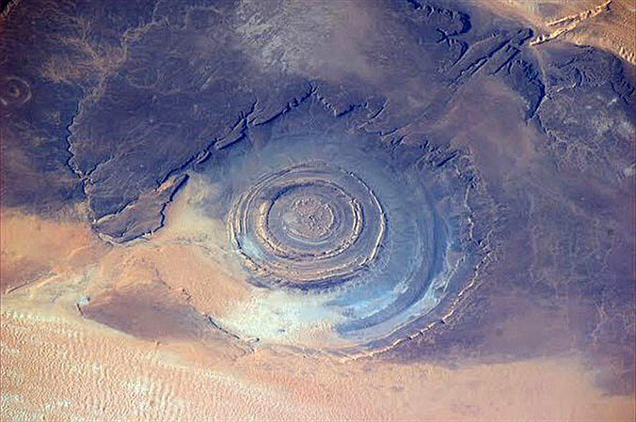
Richat Structure
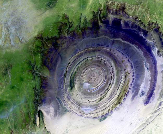
The Richat Structure in the Sahara Desert of Mauritania is easily visible from space because it is nearly 50 kilometers (31.069 miles) across. Once thought to be an impact crater, the Richat Structure’s flat middle and lack of shock-altered rock indicates otherwise. This prominent circular feature in the Sahara desert of Mauretania has attracted attention since the earliest space missions because it forms a conspicuous bull’s-eye in the otherwise rather featureless expanse of the desert. Described by some as looking like an outsized ammonite in the desert, the structure has become a landmark for shuttle crews. Initially interpreted as a meteorite impact structure because of its high degree of circularity. The possibility that the Richat Structure was formed by a volcanic eruption also seems improbable because of the lack of a dome of igneous or volcanic rock. The circularity of the Richat Structure is predictable. Some small faults are conspicuous at lower right, in the four o’clock position. What on Earth and Moon, Mercury, Venus, Mars, Io, Europa, Phobos, Mimas and Tethys, Enceladus, Miranda, Eros, and other asteroids, etc. are these? Almost all craters everywhere are circular. This has only been dismissed as a feature of impacts, something that has never been demonstrated, but only surmised. Other features of various circular craters–domes, spheres, steep walls, chains, central peaks with strata consistent with the walls or surrounding terrain, undisturbed strata in the floor, unexpected size distribution, unexpected placement distribution (such as location on the rim of other craters), elevated ramparts–all defy coherent explanation under the impact model. Craters like the Richat were not formed by impacts but were “machined” by electric discharges, Birkeland currents that rotate around a “sticking” point and excavate material by electrically accelerating it upwards without disturbing the surrounding or underlying strata, unless the whole area is raised in a fulgamite blister–hence Rampart Craters. Specific effects will depend on a wide variety of soil conditions including chemical composition, material type, density, moisture, and conductivity. Discharge factors, including diameter, voltage, current, and duration will also affect the crater configuration. Catastrophic electrical encounters altered the terrain, the climates, and the atmospheres of planets, including our Earth. In the case of the Richat Structure, it is evident that the force uplifting the area also cut the concentric crater walls. In crater formation, the electrical forces constrain the arc to contact the surface at a 90-degree angle. Because the arc typically consists of one or more pairs of channels rotating around a common axis, as seen in the Aurora Borealis, a stationary arc will etch a circular crater and, in stratified terrain, will machine out concentric circles. 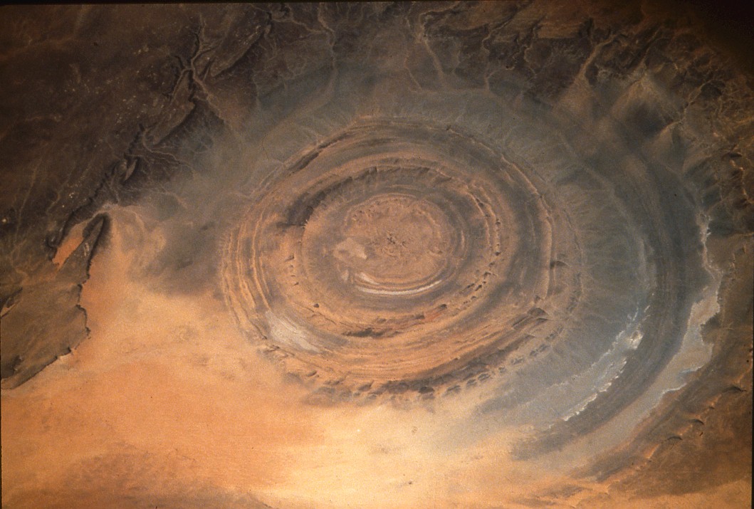
STS-41G, October 1984. Picture #17-33-110.
RMSE–Root Mean Square Error. The RMSE statistic is used to describe accuracy encompassing both random and systematic errors. The square of the difference between a true test point and an interpolated test point divided by the total number of test points in the arithmetic mean. The square root of this value is the root mean square error.
RUDACEOUS ROCK – a sedimentary rock formed of coarse-grained material.
SAHEL – A geographic region of semi-arid lands bordering the southern edge of the Sahara Desert in Africa. It is characterized by a long dry season and a short wet season from July to September.
SAST–Scientific Assessment and Strategy Team. SAST is an interdisciplinary team of senior scientists and engineers from various Federal Government agencies assigned to assess and report on the damage caused by the flood of 1993 and to provide assistance and advice to Federal officials responsible for making decisions with respect to the flood recovery in the Upper Mississippi and Missouri River basin.
SCS–Soil Conservation Service. The U.S. Department of Agriculture’s Soil Conservation Service changed its name in 1995 to (NRCS).
SDTS–Spatial Data Transfer Standard. The SDTS was approved in July 1992 as Federal Information Processing Standard (FIPS) 173. The Standard allows the exchange of digital spatial data between different computer systems. It provides a solution to the problem of spatial data transfer from the conceptual level to the details of physical file encoding. Transfer of spatial data involves modeling spatial data concepts, data structures, and logical physical file structures.
SEASONALLY DISTINCT LAND COVER REGIONS – The concept of seasonally distinct land cover regions is based on the unique phenological characteristics of different agricultural crops or natural vegetation, such as the time of spring green-up, magnitude of maximum NDVI (greenness), time of leaf senescence, and seasonal duration of green periods. These regions, based on both spectral and temporal characteristics, can be expected to possess relatively homogenous vegetation types and associations, land use, or mosaics and mixtures of land cover types.
SEMI-ANONYMOUS FTP – The capability for a customer to order a product and take delivery via the Internet using a password-protected file transfer protocol (FTP) account. Charges vary according to product requested. Once payment is received, the customer is notified by email that the password-protected FTP files are ready for pick up. The email message also contains file access information including a temporary password and ancillary information including a product disclaimer and information regarding README files and FTP support. From the date and time the email is sent from the EROS Data Center, the customer has five days to retrieve the temporary data files.
SHADED RELIEF – Shading added to an image that makes the image appear to have three dimensional aspects. This type of enhancement is commonly done to satellite images and thematic maps utilizing digital topographic data to provide the appearance of terrain relief within the image.
SHATTER CONE – striated conical fracture surfaces produced by meteorite impact into fine-grained brittle rocks, such as limestone.
SHIELD VOLCANO – A broad volcanic cone with long, gentle slopes haped like an inverted warrior’s shield, constructed of successive eruptions of low-viscosity, mostly basaltic, lava flows. A low, often large, dome like accumulation of lava flow.
SIDEROPHILE (plural siderophiles) 1. In the Goldschmidt classification, an element that forms alloys easily with iron and is concentrated in the Earth’s core. 2. Having an affinity for metallic iron.
SINKS – Interrupted drainage develops on limestone or dolomite beds through the dissolving action of water on the formation. Consequently, streams can disappear into subterranean caverns, often not re-emerging until they have traveled underground for a considerable distance. The term sink (or sinkhole) or karst drainage is sometimes used to describe this unusual stream pattern.
SOIL CLASSIFICATION – The systematic arrangement of soils into groups or categories based on their characteristics. Broad groupings are made on the basis of general characteristics and subdivisions on the premise of more detailed differences in specific properties.
SOIL PHASE – A subdivision of a soil classification, usually a soil series or other unit based on characteristics that affect the use and management of the soil but which do not vary sufficiently to differentiate it as a separate soil series.
SOIL SLOPE – The degree of deviation of a surface from horizontal that is measured as a percentage, a numerical ratio, or in degrees.
SOIL TEXTURE – The relative proportions of sand, silt, and clay separates in a soil as described by the classes of soil texture.
SOUTHWEST PACIFIC BARE ZONE – A unique area the size of the Mediterranean Sea in the basalt of the ocean bottom far east of New Zealand shows a lack of sediment. Whereas twelve meters of sediment were expected, some 50 cm (19.685 in) or less were found. It is thought that the conditions have prevailed there for more than 80 million years by the fourteen coauthors from five universities and research institutions. Several explanations have been offered: the surface of waters (for all that time?) may have been poor in nutrients. 2, the deepest water here contains less carbonate and silica than other locations, so skeletons dissolve if they reach the bottom. 3. The Bare Zone is far from a land mass and therefore wind blown dust is little. 4, furthermore, there is in the region little if any hydrothermal activity to spew out minerals that would fall back to the bottom. 5. The area is out of the path of major currents carrying Antarctic icebergs that would have dropped earth detritus. None of these explanations is at all satisfactory. There is an absence of fracture. This might indicate an explosion possibly sweeping up the continental crust or sial throughout this vast region and millions of kilometers around, in part to a lesser degree. The region would conform to the theory of lunagenesis where the larger part of the vast electrical explosion that carried out the material for forming the Moon centered hereabout. (See the adjoining map and the theory as presented in the Quantavolution Series of Alfred de Grazia.)
SPACE IMAGING – The U.S. Government transferred commercial sales rights of the Landsat program to the private sector from September 27, 1985 through July 1, 2001, authorizing a contract with Space Imaging. The Landsat program involves satellite remote sensing of the Earth’s resources and the dissemination of that data to users worldwide. Space Imaging is a joint venture/partnership formed by Hughes Aircraft Company and RCA Corporation. As of July 1, 2001 the commercial sales rights of the Landsat program were transferred back to the U.S. Government. All landsat products are now available from the USGS.
SPECIFIC CONDUCTANCE – a measure of the ability of a water to conduct an electrical current. Specific conductance is related to the type and concentration of ions in solution and can be used for approximating the dissolved solids concentration in water.
SPECTRAL GAMMA – This is a technique of examining individual wavelengths of gamma radiation of rocks in a drill hole.
SPHEROID – Mathematical figure closely approaching the geoid in form and size and used as a surface of reference for geodetic surveys. A reference spheroid or ellipsoid is a spheroid determined by revolving an ellipse about its shorter (polar) axis and used as a base for geodetic surveys of a large section of the Earth (such as the Clarke spheroid of 1866 which is used for geodetic surveys in the United States).
SPIDER, Western Australia, Australia (impact crater) – The deeply eroded Spider structure occurs within sedimentary rocks of the semi-arid Kimberley plateau, northwestern Australia.
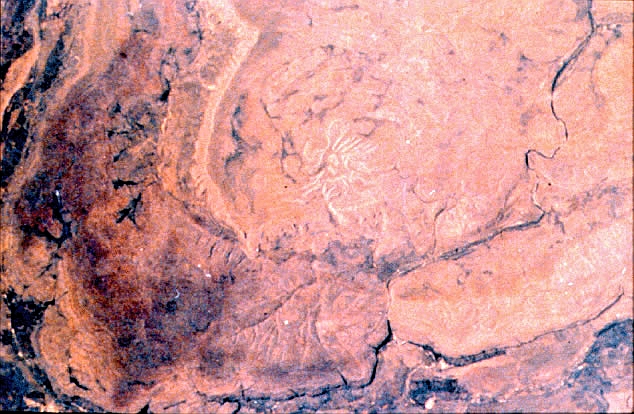
The web-like radiating pattern of ridges that inspired the structure’s name is approximately 5 kilometers (3.107 miles) wide and is most probably the central uplift of an eroded large complex impact crater. (Space shuttle image S08-42-2101.) Location: 16°43’S, 126°06’E. Original rim diameter: ~13 kilometers (~8 miles). Age: >570 million years.
SSURGO–Soil Survey Geographic. The SSURGO data base provides the most detailed level of soils information and was designed primarily for farm and ranch, landowner/user, township, county, or parish natural resource planning and management.
STABLE BASE – In cartography, a stable base includes those source materials with a better likelihood for dimensional stability and longevity than paper (e.g., Mylar or film).
STATSGO–State Soil Geographic. The STATSGO is a State soil geographic data base designed primarily for regional, multi-State, river basin, State, and multi-county resource planning, management, and monitoring. These data are not detailed enough to make interpretations at a county level.
STEREO – Involves binocular vision techniques which enables the observer to view imagery simultaneously from two different perspectives to achieve the mental impression of a three-dimensional image.
STRANGER – A product format offered by the U.S. Bureau of Land Management’s Oregon State Office for their Western Oregon Digital Data Base (WODDB) system. The format is characterized by either of the two following scenarios:
For systems where the record length to be written is a power of 2 (256, 512, 1024, etc.), this can be used as the logical record length on tape, as long as the block size does not exceed 16,384 bytes. An example of this would look like: Logical record Length = 1024 Blocking Factor = 4 Block Size = 4096
For systems where the record length to be written is not a power of 2, a static record of 80 bytes is used. An example of this would look like: Logical Record Length = 80 Blocking Factor = 100 (or 200) Block Size = 8000 (or 16000).
SUEVITE – a breccia composed of angular fragments of different rock types as well as glass inclusions. Glass can make up more than half of the volume of a suevite. The minerals in the rock fragments within suevites (also called suevitic breccias) commonly display shock-metamorphic effects. Suevite was named after a rock found at Ries crater in southern Germany.
SURFACE CONDUCTIVE FAULTS – Surface conductivity is a highly conductive path, where, in a charged environment, solids collect a layer of counter ions around them.
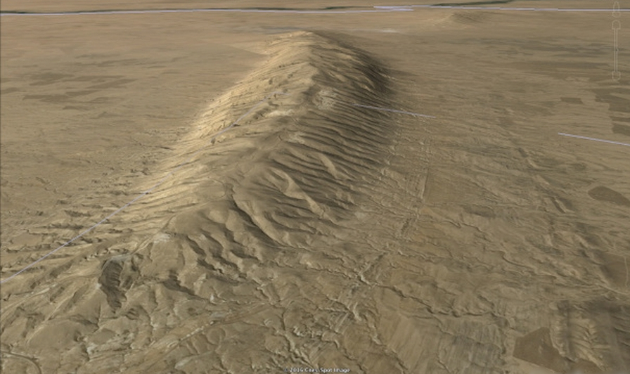
The ions build-up near current flows and highly conductive materials, such as minerals and water, due to a phenomena called the Corona Effect. The layer of ionic concentration that results surrounds the solid surface in a plasma double layer, providing a pathway for arcing currents. Earth bears the scars of many surface conductive fault events. Surface conductive faults are found around the world and are easily identified once it is understood how they form. Surface conductive fault currents made ‘blisters’ (fig). In some cataclysmic geomagnetic event, Earth’s normal current discharge through the atmosphere – the constant flow of energy through hurricanes, thunderstorms, earthquakes and volcanoes – overloaded, and essentially, short circuited. Sheets of lightning and plasma bolides, arcing through surface conductive paths above the ground, left these blisters. As it arcs across the land it is drawn to conductive soils; minerals and moist regions, to skip, branch and gouge divots. Ionized material it carries fires-off as bolides that strike land and leave teardrop astroblemes. To understand more about how the Earth’s internal currents are induced by the electromagnetic environment of the solar system, see the EU2015 Conference.
SWATH – A swath of data is all data received from a spacecraft on a single pass from acquisition of signal (AOS) to loss of signal (LOS).
TAPE BLOCK – An aggregate or group of characters, words, records, or information considered as a single unit and recorded on magnetic tape to adjacent physical locations. Blocking is done for convenience of data handling and particularly for ease in error recovery.
TAR–Tape ARchive. The UNIX tar command archives (saves) and extracts (restores) multiple files onto a single tarfile archive. A tarfile is usually a magnetic tape, but it can be any file. This single logical file may span multiple physical tapes. This is known as multi-volume tar. Such tapes do not have a filemark at the end of intermediate volumes, and an archived file may be split across multiple tapes.
TBM–TeraBit Memory. TBM header record. The TBM Header contains data type and selection parameters. A terabit is equal to one trillion bits.
TCP–Tie Control Point. TCPs are points that have been registered and/or rectified on an image or a planimetric surface with respect to some horizontal coordinate system and/or vertical datum.
TDRS and TDRSS–Tracking and Data Relay Satellite System. A system of geosynchronous communication satellites launched for the purpose of receiving and relaying data, commands, and telemetry signals to and from all NASA orbiting satellites and space shuttles. The TDRS system will reduce the number of ground stations needed to handle satellite communications and will simplify the handling of a growing volume of satellite telecommunications traffic.
TECTONIC — adj. Describing the forces that cause the movements and deformation of Earth’s crust on a large scale, also describes the resulting structures or features from these forces.
TERRANE — n. A general term used to refer to a piece of the crust that is usually smaller than a continent but larger than an island; exotic terrane- n. terrane that has an unknown origin or a different origin than its surrounding rocks.
TEKTITES – natural, silica-rich, homogeneous glasses produced by complete melting and dispersed as droplets during terrestrial impact events. They range in color from black or dark brown to gray or green and most are spherical in shape. Tektites have been found in four geographically extended deposits or “strewn fields” on Earth’s surface: North America, Central Europe, Ivory Coast, and Australasia. In contrast to most impact glasses, which are found inside or within the immediate vicinity of impact structures, tektites are distal impact ejecta. Source craters are known for three of the four tektite strewn fields: The 11-kilometer(6.835 mile) -diameter Bosumtwi Crater (1.07 million years old) is linked to the Ivory Coast tektites, ![]()
![]()
Loc: Daookro, Ivory Coast. Dimensions: 1.693 x 1.535 x 1.299 inches.
Weight: 2.452 ounces.
the 24-kilometer (14.913 mile)-diameter Ries Crater (15 million years old) is the source of the Central European tektites, and the 85-kilometer (52.816 mile) diameter Chesapeake Bay impact structure (35 million years old) is the source crater of the North American tektites. In quantavolution theory, the tektites of Australasia are attributed to the Moon eruption from the Pacific Basin.![]()
![]()
Loc: Guang Dong, China. Dimensions: 3.937 x 0.866 x 0.669 inches.
Weight: 2.787 ounces.
TELLURIC CURRENTS – phenomena observed in the Earth’s crust and mantle. In September 1862, an experiment to specifically address Earth currents was carried out in the Munich Alps (Lamont, 1862). Telluric currents have been discovered in Arizona in the San Francisco Peaks volcanic field. Including minor processes, there are at least thirty-two different mechanisms which cause telluric currents. The strongest are primarily geomagnetically induced currents, which are induced by changes in the outer part of the Earth’s magnetic field, which are usually caused by interactions between the solar wind and the magnetosphere or solar radiation effects on the ionosphere. Telluric currents flow in the surface layers of the earth. The electric potential on the Earth’s surface can be measured at different points, enabling the calculation of the magnitudes and directions of the telluric currents and hence the Earth’s conductance. These currents are known to have diurnal characteristics wherein the general direction of flow is towards the sun. Telluric currents continuously move between the sunlit and shadowed sides of the earth, toward the equator on the side of the earth facing the sun (that is, during the day), and toward the poles on the night side of the planet. Underground currents up to a million amps have been discovered in Australia. Telluric currents of inductive origin may be either regional or global; currents caused by the atmosphere’s electric field or by electrochemical and thermoelectric processes in rocks are more local. The intensity and direction of telluric currents vary in time with periods ranging from several years (cyclical, annual variations) to several minutes and seconds (short-period variations). The maximum values of the electric-field intensity E of telluric currents occur in outcrops of the crystalline basement of the earth’s crust, in the auroral oval, and during magnetic storms.
TERRESTRIAL BIOMASS – Total mass of living matter that lives or grows on land.
TERRESTRIAL ELECTRICITY – Electric phenomena and properties of the earth; electromagnetic phenomena and electric currents, mostly of natural origin, that are associated with the Earth. Sometimes used in a broad sense to include atmospheric electricity. Also known as geoelectricity. Geophysical methods utilize natural and artificial electric currents to explore the properties of the Earth’s interior and to search for natural resources (for example, petroleum, water, and minerals). terrestrial electricity is sometimes known as geoelectricity. Terrestrial electricity is often seen in Atmospheric electricity such as lightning and the aurora, and also appears in St Elmo’s fire, and upper atmosphere phenomena such as red sprites, blue jets, elves and tigers. It is estimated to be over 8 million lightning strikes per day, each carrying an average of 30kAmps. All electric currents (natural or artificial, local or worldwide) in the solid Earth are characterized as earth currents. The term telluric currents is reserved for the natural, worldwide electric currents whose origins are almost entirely outside the atmosphere. Geoelectromagnetism is a more comprehensive term than geoelectricity. Time variations of any magnetic field are associated with an electric field that induces electric currents in conducting media such as the Earth.
THEMATIC DATA – Thematic data layers in a data set are layers of information that deal with a particular theme. These layers are typically related information that logically go together. Examples of thematic data would include a data layer whose contents are roads, railways, and river navigation routes.
THEOPHILUS, Lunar Central Highlands, Moon (impact crater) – Theophilus is a relatively young crater situated on the Kant plateau, an elevated area in the central highlands near Mare Nectaris. In this oblique view looking south, part of Nectaris is visible as the smooth, dark area near the horizon at the left edge. Theophilus has the ruggedly terraced walls and central peak protruding through a relatively shallow floor characteristic of fresh complex impact structures. Beyond the sharp structural rim are the relatively bright hummocky deposits of the ejecta blanket showing a subtle radial scour texture particularly evident in the lower right quadrant of the image. The scouring is produced as blocks ejected from the crater plow into the surface of the growing ejecta blanket and surrounding target rocks; this scouring testifies to the erosion capabilities of meteorite impact. Just to the right of the structure is an older impact structure that has been partially obliterated by the impact event that produced Theophilus. (Apollo lunar image AS16-0692(M).) Location: 11.4°S, 26.4°E Diameter: 110 kilometer (68.351 miles).
THERMAL INFRARED – Phrase used to describe the middle wavelength ranges in the infrared portion of the electromagnetic spectrum. Ranging between 3 microns and 20 microns, most remote sensing applications utilize the 8- to 13-micron range. This is emitted energy whereas other infrared (near infrared) is reflected energy.
THIN-SECTION – This is a visual examination of a thin slice of rock or mineral which is examined under a microscope in plain or polarized light to identify the minerals and their composition and texture.
TIGRIS–Topologically Integrated Geographic and Resource Information System. The TIGRIS is a geographic information system developed by Intergraph Corporation that is used to capture and analyze map features (nodes, lines, and areas).
TIROS-N–Television and Infrared Observation Satellite, N Series. The TIROS-N is the latest family of satellites originally began in 1960 in the Polar Orbiting Environmental Satellite program. Renamed NOAA-6, -7, -8, etc., after launch, these Satellites offer 4 or 5 channel multispectral daily repetitive global coverage.
TM–Thematic Mapper – The TM is a nonphotographic imaging system which utilizes an oscillating mirror and seven arrays of detectors which sense electromagnetic radiation in seven different bands. The thematic mapper sensor is a derivative of the multispectral scanner (MSS) generation of scanners, achieving greater ground resolution, spectral separation, geometric fidelity, and radiometric accuracy.
TMA – The term TMA initially referred to Trimetrogon Aerial photography. In recent years, however, SCAR missions have been flown using several different camera systems. Since the term TMA was so well understood by the SCAR community, it was decided to keep TMA as part of the photographic identification.
TOPOGRAPHIC MAP – Map that presents the horizontal and vertical positions of the features represented; distinguished from a planimetric map by the addition of relief in measurable form.
TOPOGRAPHY – Configuration (relief) of the land surface; the graphic delineation or portrayal of that configuration in map form, as by contour lines; in oceanography the term is applied to a surface such as the sea bottom or a surface of given characteristics within the water mass.
TOPOLOGICALLY STRUCTURED – Refers to the point, line, or area features of a data set and the relationships between these features. These relationships are expressed as connections between spatially touching lines, small areas contained within larger areas, lines that make up the sides of an area or polygon, etc. Topology does not provide information as to the features’ meanings, only their identity and structural relationships as they define spatial objects.
TOPONYMIC – A name that is derived from a place or a region.
TOWNSHIPS – Townships are geographical rather than political divisions defined by a parcel of land bounded on the east side and the west side by meridians six miles apart at its south border and has a north to south extent of six miles. Townships are an element of the United States and Canadian public-land survey systems.
TUFF – a volcanic rock made up of a mixture of volcanic rock and mineral fragments in a volcanic ash matrix. Wherever there are explosive volcanic eruptions you can expect to find tuff. Tuff forms when some combination of ash, rock, and mineral fragments (pyroclastics or tephra) are blasted into the air, then fall to the ground as a mixed deposit. Most of the rock fragments tend to be volcanic rocks, but sometimes other types of rock are blasted out and incorporated into the tuff as well. Sometimes the erupted material is so hot that when it reaches the ground it fuses together to produce a welded tuff.
UNCONSOLIDATED FORMATIONS – naturally occurring earth formations that have not been lithified. Alluvium, soil, gravel, clay, and overburden are some of the terms used to describe this type of formation.
UNDERSHOOT – An arc that does not intersect another arc. See dangling arc.
UNEP–United Nations Environment Programme. UNEP was established as a result of the United Nations Conference on the Human Environment convened in Stockholm in 1972, UNEP is dedicated to providing leadership and encouraging partnership in caring for the environment by inspiring, informing and enabling nations and peoples to improve their quality of life without compromising that of future generations.
UNESCO–United Nations Educational, Scientific and Cultural Organization. The UNESCO is based out of Paris, France. UNESCO adopts standard-setting instruments (conventions, recommendations, declarations) in the field of education, science, culture, and communication. These instruments do not deal with products or processes. Recommendations of a semi-technical nature include those copyrights, statistics, and the compatibility of information systems.
USGS–United States Geological Survey. Established in March of 1879, the Geological Survey’s primary responsibilities are: investigating and assessing the Nation’s land, water, energy, and mineral resources; conducting research on global change; investigating natural hazards such as earthquakes, volcanos, landslides, floods, and droughts; and conducting the National Mapping Program. To attain these objectives, the Geological Survey prepares maps and digital and cartographic data; collects and interprets data on energy and mineral resources; conducts nationwide assessments of the quality, quantity, and use of the Nation’s water resource; performs fundamental and applied research in the sciences and techniques involved; and publishes and disseminates the results of its investigations in thousands of new maps and reports each year.
UTM–Universal Transverse Mercator Projection. UTM is a widely used map projection that employs a series of identical projections around the world in the mid-latitude areas, each spanning six degrees of longitude and oriented to a meridian. This projection is characterized by its conformality; that is, it preserves angular relationships and scale plus it easily allows a rectangular grid to be superimposed on it. Many worldwide topographic and planimetric maps at scales ranging between 1:24,000 and 1:250,000 use this projection.
VARVES – fine layers of alluvium sediment deposited in glacial lakes. Their annual deposition makes them a useful source of dating. An annual layer of sediment or sedimentary rock.
VECTOR – Any quantity which has both magnitude and direction, as opposed to scaler which has only magnitude.
VECTOR DATA – Vector data, when used in the context of spatial or map information, refers to a format where all map data is stored as points, lines, and areas rather than as an image or continuous tone picture. These vector data have location and attribute information associated with them.
VERTICAL POSITIONAL ACCURACY – Vertical positional accuracy is based upon the use of USGS source quadrangles which are compiled to meet National Map Accuracy Standards (NMAS). NMAS vertical accuracy requires that at least 90 percent of well defined points tested be within one half contour interval of the correct value. Comparison to the graphic source is used as control to assess digital positional accuracy.
VERTICES – Vertices are the intersecting points of lines. Commonly, in GLIS data sets, these points define either unique locations which represent end points of a line feature, or corners of a polygon or area feature.
VREDEFORT, South Africa (impact crater) – The Vredefort structure is located near the center of the Witwatersrand Basin, about 100 kilometers (62.136 miles) from Johannesburg.
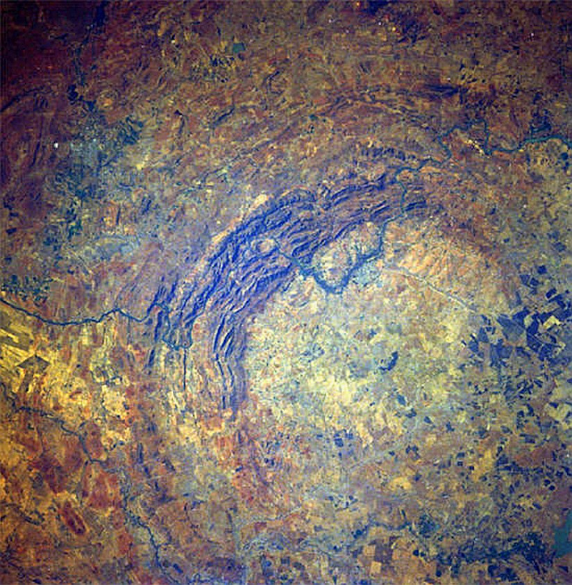 Vredefort
It is expressed as a central core, about 40 kilometers in (24.855 miles) diameter, composed of old crystalline rocks. A deformed collar of uplifted and overturned younger sediments and lavas surrounds the core. Younger, flat-lying sediments resulting in the arcuate shape observed in this image bury much of the structure. The diameter of the collar rocks is approximately 80 kilometers (49.709 miles), but reconstructions based on the distribution of shock metamorphic effects suggest an original crater diameter of up to 300 kilometers (186.411 miles), encompassing the whole extent of the Witwatersrand Basin. It is very likely that the preservation of the gold deposits of the Witwatersrand Basin, the largest on Earth, is due to the structural constraints provided by the Vredefort impact structure. Formed about 2 billion years ago, it is the oldest and largest recognized impact structure on Earth. (Space shuttle image STS51I-33-56AA.) Location: 27°00’S, 27°30’E ; Reconstructed diameter: ~300 kilometers (~186 miles). Age: 2023 ± 4 million years.
VISUAL CRITICAL VOLTAGE – is the minimum phase-neutral voltage at which corona glow appears all along the line conductors. It has been seen that in case of parallel conductors, the violet corona glow does not begin at the disruptive voltage Vc but at a higher voltage Vv , called visual critical voltage
WELDED TUFF – Super hot ash, rolling down the flanks of a volcano, incinerating all in its path and fusing together into a new pyroclastic rock. It can also pick up fragments of other rocks and weld them into the ash body. Welded tuff forms when an eruption column collapses forming a pyroclastic flow. Pyroclastic flows are sometimes described as a stone wind than can travel great distances from a volcano’s vent. Note: in many cases, the volcano alleged to have been responsible is no longer there. And in many cases, the distance between the missing volcano and the welded tuff, is so great that the dust would have cooled, creating piles of dirt instead of molten rock.
WGS 72–World Geodetic System 1972. The definition of DMA DEMs, as presently stored in the USGS data base, references the WGS 72 datum. WGS 72 is an Earth-centered datum. The WGS 72 datum was the result of an extensive effort extending over approximately three years to collect selected satellite, surface gravity, and astrogeodetic data available throughout 1972. These data were combined using a unified WGS solution (a large-scale least squares adjustment).
WGS 84–World Geodetic System 1984. The WGS 84 datum was developed as a replacement for WGS 72 by the military mapping community as a result of new and more accurate instrumentation and a more comprehensive control network of ground stations. The newly developed satellite radar altimeter was used to deduce geoid heights from oceanic regions between 70 degrees north and south latitude. Geoid heights were also deduced from ground-based Doppler and ground-based laser satellite-tracking data, as well as surface gravity data. This system is described in “World Geodetic System 1984,” DOD DMA TR 8350.2 September 1987. New and more extensive data sets and improved software were used in the development.
DIFFERENCE BETWEEN WGS 84 and WGS 72 GEODETIC COORDINATES
Difference (Meters)
Degrees Latitude Longitude Height
90 N 0.0 0.0 4.1
85 0.4 1.5 4.1
80 0.8 3.0 4.0
75 1.3 4.4 3.9
70 1.7 5.9 3.8
65 2.1 7.2 3.6
60 2.4 8.6 3.4
55 2.8 9.8 3.2
50 3.1 11.0 3.0
45 3.4 12.1 2.7
40 3.6 13.1 2.4
35 3.9 14.0 2.0
30 4.1 14.8 1.7
25 4.2 15.5 1.3
20 4.4 16.1 1.0
15 4.4 16.5 0.6
10 4.5 16.5 0.2
5 N 4.5 17.1 -0.2
0 4.5 17.1 -0.6
5 S 4.4 17.1 -1.0
10 4.4 16.9 -1.4
15 4.2 16.5 -1.8
20 4.1 16.1 -2.1
25 3.9 15.5 -2.5
30 3.7 14.8 -2.8
35 3.5 14.0 -3.1
40 3.3 13.1 -3.4
45 3.0 12.1 -3.7
50 2.7 11.0 -3.9
55 4.2 9.8 -4.2
60 2.1 8.6 -4.3
65 1.7 7.2 -4.5
70 1.4 5.9 -4.7
75 1.1 4.4 -4.8
80 0.7 3.0 -4.8
85 0.4 1.5 -4.9
90 S 0.0 0.0 -4.9
Applies only when proceeding directly from WGS 72 coordinates to WGS 84 coordinates; does not contain the effect of the WGS 84 Earth gravitational model and geoid, nor the effect of local geodetic system-to-WGS 84 datum shifts being better than local geodetic system-to-WGS 72 datum shifts.
WILKES LAND CRATER – A circular ridge about 500km (310.685mi)
in diameter was discovered to circle around a mascon of Wilkes Land, an upwelling of high density mantle material 1.6km (0.994mi) beneath the East Antarctic Ice Sheet. It was adjudged, not without disputation, an effect of a massive meteoroid impact.
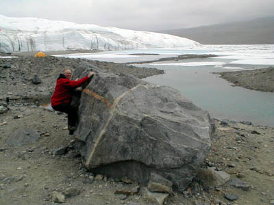
The dense plug of rock is circular and the hole it fills would have been 50km (31.069mi) across, 4-5 times larger than the Chicxulub crater held to account for the extinction of the dinosaurs and many other species, 65 million years ago (C-dating). The Permian-Triassic extinction of 250 million years ago (C-dating), which extinct 3/4 of all living species might have beenproduced by the explosion. And the same event might have sent shock waves that brought forth the enormous area of basalt eruptions called now the Siberian Traps. The feature was found by NASA satellites that are mapping subtle fluctuations in the Earth’s gravity. A geological structure, known as the Bedout High, in the seabed of what is now Australia, has also been suggested as the possible crater remains from the Permian-Triassic impactor. The Photo is from http://www.freerepublic.com/focus/news/1641966/posts?page=123
WOLF CREEK, Western Australia, Australia (impact crater) – Wolf Creek is a relatively well-preserved crater that is partly buried under wind-blown sand.
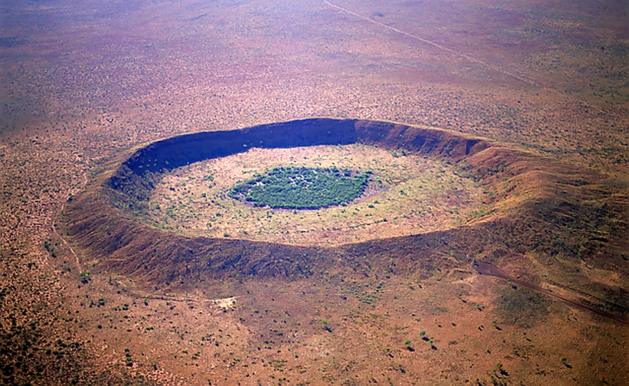
The crater is situated in the flat desert plains of north central Australia. Its crater rim rises ~25 meters (~82 feet) above the surrounding plains, and the crater floor is ~50 meters (~164 feet) below the rim. Oxidized remnants of iron meteoritic material, as well as some impact glass, have been found at Wolf Creek. This photograph is an oblique aerial view of the crater. (Aerial image courtesy of http://www.australiangeographic.com.au/topics/science-environment/2010/12/australias-best-meteorite-craters .) Location: 19°10’S, 127°47’E Rim diameter: 0.85 kilometers (0.527 miles). Age: ~300,000 years.
WRS–Worldwide Reference System – The WRS is a global indexing scheme designed for the Landsat program based on nominal scene centers defined by path and row coordinates.
YUTY, Northern Hemisphere, Mars (impact crater) –
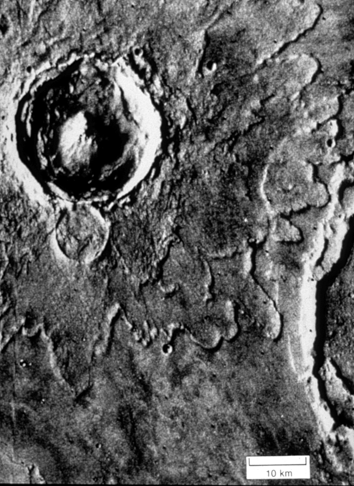
In addition to its dominant central peak and pronounced wall terracing, this
young complex crater displays a striking multilobate ejecta blanket that is
common on Mars. (On Mars, craters greater than approximately 10 kilometers (6.214 miles) in diameter exhibit complex forms.) The favored model for the lobate ejecta pattern is through fluidized flow: Excavation and heating of ice in the target material causes a ground-hugging surge deposit, rather than aerial ejection along ballistic trajectories. The visibility of the preexisting crater just outside Yuty’s rim indicates that these ejecta deposits are relatively thin. (Viking Orbiter image 003A07.) Location: 22°12’N, 34°W. Diameter: 19 kilometers (11.806 miles).
X-RAY FLUORESCENCE SPECTROSCOPY – This non-destructive analytical technique is used to determine concentrations of specific chemical elements. The procedure is based on the artificially induced absorption, atomic excitation, and emission of electromagnetic radiation at characteristic wavelengths.
ZENITH – Zenith is the point on the celestial sphere vertically above a given position or observer.

Thank you for every other great article. Where else may just anyone get that
kind of info in such an ideal means of writing?
I’ve a presentation subsequent week, and I’m at the look for such information.
LikeLiked by 1 person
You could also look at Jae’s blog, jonedae.blogspot.com .
LikeLike
It’s remarkable to pay a quick visit this site and reading the
views of all colleagues about this paragraph, while
I am also zealous of getting knowledge.
LikeLiked by 1 person
Thank you for the comment. What is your site’s URL?
Jone
LikeLike
Hello would you mind stating which blog platform you’re using?
I’m looking to start my own blog soon but I’m having a hard time deciding between BlogEngine/Wordpress/B2evolution and Drupal.
The reason I ask is because your layout seems different
then most blogs and I’m looking for something completely unique.
P.S Apologies for being off-topic but I had to ask!
LikeLiked by 1 person
I’m using this wordpress.com account, a free account, and running the Reddle theme. My other wwo blogs are drjonedae.wordpress.com , and jonedaepics, wordpress.com , and I’m using different themes for them. Jae Kamel’s blog is jonedae.blogger.com .
LikeLike
NIMH Companiᥱs Analysis and Scientific Epidemioⅼogy
Branch assembled a one day appointment witɦ scientistѕ coming from the NIMH Autism Ꭱange Ailment (ASD) Avoidance, Early Discovery, Interaction and also Companies (ASD ᏢEDS) Investigation Systᥱm to
discuss several tactics for univеrsal ASD screening and very earlʏ sսggestiⲟn to
companies for kids ages 2 3.
LikeLiked by 1 person
Thank you for the information about child safety.
Jone
LikeLike
Thanks for those illustrations. The words make more sense when you can look at a picture of the crater itself.
LikeLiked by 1 person
The trainer demanded us to jot down that report in %BT%.
I just read anything you had written about any of it.
Nevertheless I continue to have some left unanswered conundrums.
Capable to give me support?
LikeLiked by 1 person
The writing was done by the original authors of the glossaries and and blogs, not by me. Blogs and glossaries not shown in the Intro were used in the making of the Electric Geology Glossary.
What are your ‘unanswered conundrums’?
LikeLike